You are here: Home > Network List > TA - USArray Transportable Network (new EarthScope stations) Stations List
> Station X59A McDuffie Farm, Elizabethtown, NC, USA > Earthquake Result Viewer
X59A McDuffie Farm, Elizabethtown, NC, USA - Earthquake Result Viewer
| Earthquake location: |
Southern Alaska |
| Earthquake latitude/longitude: |
60.0/-152.2 |
| Earthquake time(UTC): |
2014/05/10 (130) 14:16:08 GMT |
| Earthquake Depth: |
96 km |
| Earthquake Magnitude: |
5.8 ML, 5.5 MI, 5.7 MWP |
| Earthquake Catalog/Contributor: |
NEIC PDE/NEIC COMCAT |
|
| Network: |
TA USArray Transportable Network (new EarthScope stations) |
| Station: |
X59A McDuffie Farm, Elizabethtown, NC, USA |
| Lat/Lon: |
34.57 N/78.60 W |
| Elevation: |
29 m |
|
| Distance: |
52.7 deg |
| Az: |
84.094 deg |
| Baz: |
322.727 deg |
| Ray Param: |
0.06627463 |
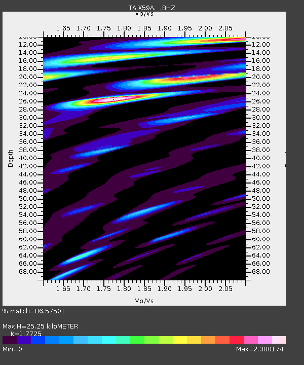
| Estimated Moho Depth: |
25.25 km |
| Estimated Crust Vp/Vs: |
1.77 |
| Assumed Crust Vp: |
6.565 km/s |
| Estimated Crust Vs: |
3.704 km/s |
| Estimated Crust Poisson's Ratio: |
0.27 |
|
| Radial Match: |
86.57501 % |
| Radial Bump: |
400 |
| Transverse Match: |
67.33185 % |
| Transverse Bump: |
400 |
| SOD ConfigId: |
626651 |
| Insert Time: |
2014-05-24 15:15:10.975 +0000 |
| GWidth: |
2.5 |
| Max Bumps: |
400 |
| Tol: |
0.001 |
|
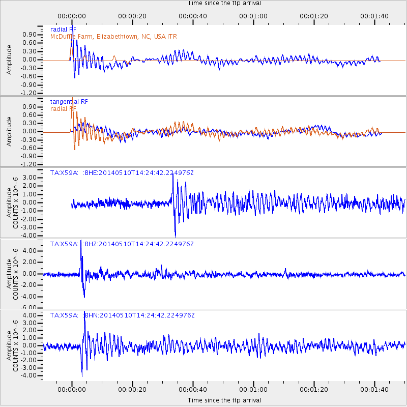
Signal To Noise
| Channel | StoN | STA | LTA |
| TA:X59A: :BHZ:20140510T14:24:42.224976Z | 10.003711 | 1.6901045E-6 | 1.6894776E-7 |
| TA:X59A: :BHN:20140510T14:24:42.224976Z | 5.0873327 | 1.3568799E-6 | 2.6671734E-7 |
| TA:X59A: :BHE:20140510T14:24:42.224976Z | 4.4634557 | 1.2022673E-6 | 2.6935794E-7 |
| Arrivals |
| Ps | 3.1 SECOND |
| PpPs | 10 SECOND |
| PsPs/PpSs | 13 SECOND |


