You are here: Home > Network List > TA - USArray Transportable Network (new EarthScope stations) Stations List
> Station Y52A Lilburn, GA, USA > Earthquake Result Viewer
Y52A Lilburn, GA, USA - Earthquake Result Viewer
| Earthquake location: |
Southern Alaska |
| Earthquake latitude/longitude: |
60.0/-152.2 |
| Earthquake time(UTC): |
2014/05/10 (130) 14:16:08 GMT |
| Earthquake Depth: |
96 km |
| Earthquake Magnitude: |
5.8 ML, 5.5 MI, 5.7 MWP |
| Earthquake Catalog/Contributor: |
NEIC PDE/NEIC COMCAT |
|
| Network: |
TA USArray Transportable Network (new EarthScope stations) |
| Station: |
Y52A Lilburn, GA, USA |
| Lat/Lon: |
33.86 N/84.06 W |
| Elevation: |
286 m |
|
| Distance: |
50.5 deg |
| Az: |
89.234 deg |
| Baz: |
322.862 deg |
| Ray Param: |
0.06767805 |
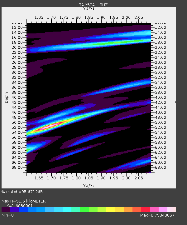
| Estimated Moho Depth: |
51.5 km |
| Estimated Crust Vp/Vs: |
1.69 |
| Assumed Crust Vp: |
6.719 km/s |
| Estimated Crust Vs: |
3.988 km/s |
| Estimated Crust Poisson's Ratio: |
0.23 |
|
| Radial Match: |
95.671265 % |
| Radial Bump: |
333 |
| Transverse Match: |
66.937065 % |
| Transverse Bump: |
400 |
| SOD ConfigId: |
626651 |
| Insert Time: |
2014-05-24 15:15:20.197 +0000 |
| GWidth: |
2.5 |
| Max Bumps: |
400 |
| Tol: |
0.001 |
|
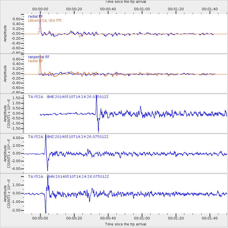
Signal To Noise
| Channel | StoN | STA | LTA |
| TA:Y52A: :BHZ:20140510T14:24:26.075012Z | 37.385933 | 1.7823095E-6 | 4.767326E-8 |
| TA:Y52A: :BHN:20140510T14:24:26.075012Z | 14.763512 | 8.385758E-7 | 5.6800562E-8 |
| TA:Y52A: :BHE:20140510T14:24:26.075012Z | 12.621765 | 6.9105386E-7 | 5.475097E-8 |
| Arrivals |
| Ps | 5.6 SECOND |
| PpPs | 19 SECOND |
| PsPs/PpSs | 25 SECOND |


