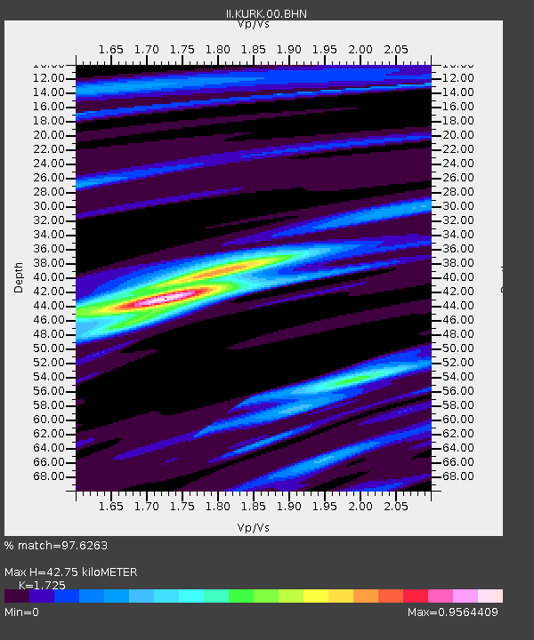
KURK Kurchatov, Kazakhstan - Earthquake Result Viewer
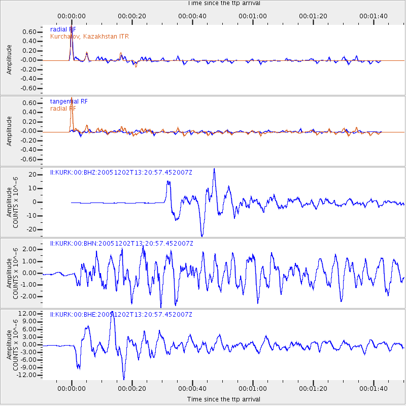
Earthquake location: Near East Coast Of Honshu, Japan
Earthquake latitude/longitude: 38.1/142.1
Earthquake time(UTC): 2005/12/02 (336) 13:13:09 GMT
Earthquake Depth: 29 km
Earthquake Magnitude: 6.1 MB, 6.3 MS, 6.5 MW, 6.4 MW
Earthquake Catalog/Contributor: WHDF/NEIC
Network: II Global Seismograph Network (GSN - IRIS/IDA)
Station: KURK Kurchatov, Kazakhstan
Lat/Lon: 50.72 N/78.62 E
Elevation: 184 m
Distance: 45.7 deg
Az: 307.391 deg
Baz: 80.452 deg
Ray Param: 0.07102988
Estimated Moho Depth: 42.75 km
Estimated Crust Vp/Vs: 1.73
Assumed Crust Vp: 6.552 km/s
Estimated Crust Vs: 3.799 km/s
Estimated Crust Poisson's Ratio: 0.25
Radial Match: 97.6263 %
Radial Bump: 265
Transverse Match: 91.90542 %
Transverse Bump: 400
SOD ConfigId: 2422
Insert Time: 2010-03-01 22:04:43.176 +0000
GWidth: 2.5
Max Bumps: 400
Tol: 0.001

Signal To Noise

ChannelStoNSTALTA
II:KURK:00:BHN:20051202T13:20:57.452007Z7.21660235.143118E-77.126786E-8
II:KURK:00:BHE:20051202T13:20:57.452007Z46.557914.5801035E-69.8374336E-8
II:KURK:00:BHZ:20051202T13:20:57.452007Z84.779618.836236E-61.0422596E-7
Arrivals
Ps5.1 SECOND
PpPs17 SECOND
PsPs/PpSs22 SECOND