You are here: Home > Network List > UU - University of Utah Regional Network Stations List
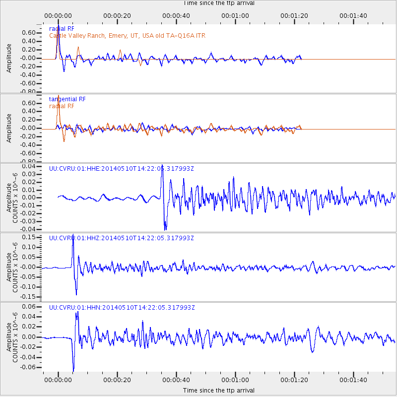
> Station CVRU Castle Valley Ranch, Emery, UT, USA old TA-Q16A > Earthquake Result Viewer
CVRU Castle Valley Ranch, Emery, UT, USA old TA-Q16A - Earthquake Result Viewer
| Earthquake location: |
Southern Alaska |
| Earthquake latitude/longitude: |
60.0/-152.2 |
| Earthquake time(UTC): |
2014/05/10 (130) 14:16:08 GMT |
| Earthquake Depth: |
96 km |
| Earthquake Magnitude: |
5.8 ML, 5.5 MI, 5.7 MWP |
| Earthquake Catalog/Contributor: |
NEIC PDE/NEIC COMCAT |
|
| Network: |
UU University of Utah Regional Network |
| Station: |
CVRU Castle Valley Ranch, Emery, UT, USA old TA-Q16A |
| Lat/Lon: |
38.92 N/111.17 W |
| Elevation: |
1912 m |
|
| Distance: |
33.2 deg |
| Az: |
110.84 deg |
| Baz: |
322.994 deg |
| Ray Param: |
0.07805002 |
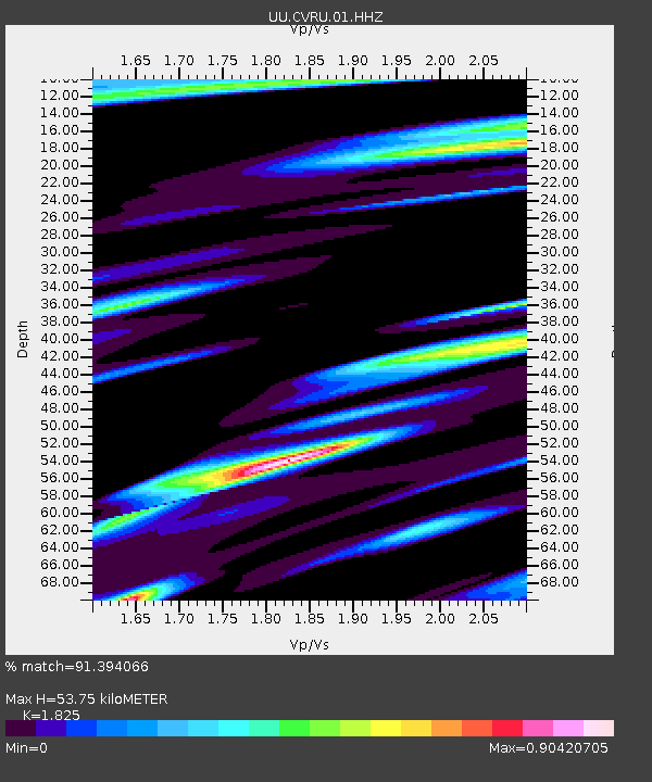
| Estimated Moho Depth: |
53.75 km |
| Estimated Crust Vp/Vs: |
1.83 |
| Assumed Crust Vp: |
6.207 km/s |
| Estimated Crust Vs: |
3.401 km/s |
| Estimated Crust Poisson's Ratio: |
0.29 |
|
| Radial Match: |
91.394066 % |
| Radial Bump: |
323 |
| Transverse Match: |
72.98092 % |
| Transverse Bump: |
390 |
| SOD ConfigId: |
626651 |
| Insert Time: |
2014-05-24 15:20:20.972 +0000 |
| GWidth: |
2.5 |
| Max Bumps: |
400 |
| Tol: |
0.001 |
|
Signal To Noise
| Channel | StoN | STA | LTA |
| UU:CVRU:01:HHZ:20140510T14:22:05.317993Z | 8.297404 | 1.34636355E-8 | 1.6226324E-9 |
| UU:CVRU:01:HHN:20140510T14:22:05.317993Z | 1.6933607 | 2.9358724E-9 | 1.7337549E-9 |
| UU:CVRU:01:HHE:20140510T14:22:05.317993Z | 1.676099 | 3.1698077E-9 | 1.8911817E-9 |
| Arrivals |
| Ps | 7.7 SECOND |
| PpPs | 23 SECOND |
| PsPs/PpSs | 30 SECOND |


