You are here: Home > Network List > 7A - Mid-Atlantic Geophysical Integrative Collaboration Stations List
> Station PVGR Lower Salem, Ohio USA > Earthquake Result Viewer
PVGR Lower Salem, Ohio USA - Earthquake Result Viewer
| Earthquake location: |
Off Coast Of Jalisco, Mexico |
| Earthquake latitude/longitude: |
18.7/-106.8 |
| Earthquake time(UTC): |
2015/02/22 (053) 14:23:14 GMT |
| Earthquake Depth: |
10 km |
| Earthquake Magnitude: |
6.2 MO |
| Earthquake Catalog/Contributor: |
NEIC PDE/NEIC ALERT |
|
| Network: |
7A Mid-Atlantic Geophysical Integrative Collaboration |
| Station: |
PVGR Lower Salem, Ohio USA |
| Lat/Lon: |
39.57 N/81.38 W |
| Elevation: |
0.0 m |
|
| Distance: |
30.2 deg |
| Az: |
41.226 deg |
| Baz: |
233.912 deg |
| Ray Param: |
0.07938609 |
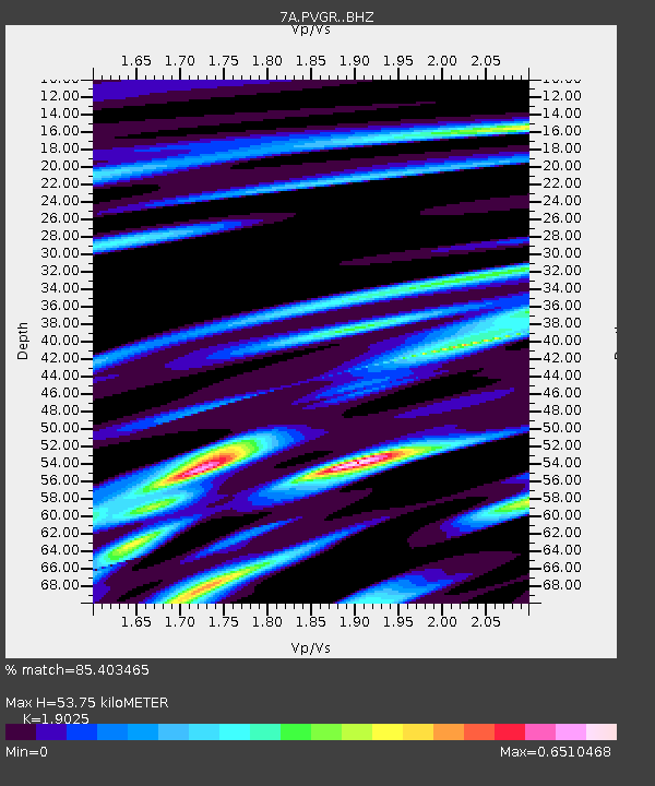
| Estimated Moho Depth: |
53.75 km |
| Estimated Crust Vp/Vs: |
1.90 |
| Assumed Crust Vp: |
6.207 km/s |
| Estimated Crust Vs: |
3.263 km/s |
| Estimated Crust Poisson's Ratio: |
0.31 |
|
| Radial Match: |
85.403465 % |
| Radial Bump: |
263 |
| Transverse Match: |
72.17461 % |
| Transverse Bump: |
400 |
| SOD ConfigId: |
7019011 |
| Insert Time: |
2019-04-17 00:49:07.331 +0000 |
| GWidth: |
2.5 |
| Max Bumps: |
400 |
| Tol: |
0.001 |
|

Signal To Noise
| Channel | StoN | STA | LTA |
| 7A:PVGR: :BHZ:20150222T14:28:55.550012Z | 4.9921846 | 1.4278768E-6 | 2.8602244E-7 |
| 7A:PVGR: :BHN:20150222T14:28:55.550012Z | 2.69067 | 6.0612035E-7 | 2.2526746E-7 |
| 7A:PVGR: :BHE:20150222T14:28:55.550012Z | 4.5199986 | 9.54303E-7 | 2.1112905E-7 |
| Arrivals |
| Ps | 8.4 SECOND |
| PpPs | 23 SECOND |
| PsPs/PpSs | 32 SECOND |


