You are here: Home > Network List > 7A - Mid-Atlantic Geophysical Integrative Collaboration Stations List
> Station WINE Liberty, Virginia USA > Earthquake Result Viewer
WINE Liberty, Virginia USA - Earthquake Result Viewer
| Earthquake location: |
Off Coast Of Jalisco, Mexico |
| Earthquake latitude/longitude: |
18.7/-106.8 |
| Earthquake time(UTC): |
2015/02/22 (053) 14:23:14 GMT |
| Earthquake Depth: |
10 km |
| Earthquake Magnitude: |
6.2 MO |
| Earthquake Catalog/Contributor: |
NEIC PDE/NEIC ALERT |
|
| Network: |
7A Mid-Atlantic Geophysical Integrative Collaboration |
| Station: |
WINE Liberty, Virginia USA |
| Lat/Lon: |
38.16 N/78.32 W |
| Elevation: |
119 m |
|
| Distance: |
31.5 deg |
| Az: |
46.074 deg |
| Baz: |
239.989 deg |
| Ray Param: |
0.079061404 |
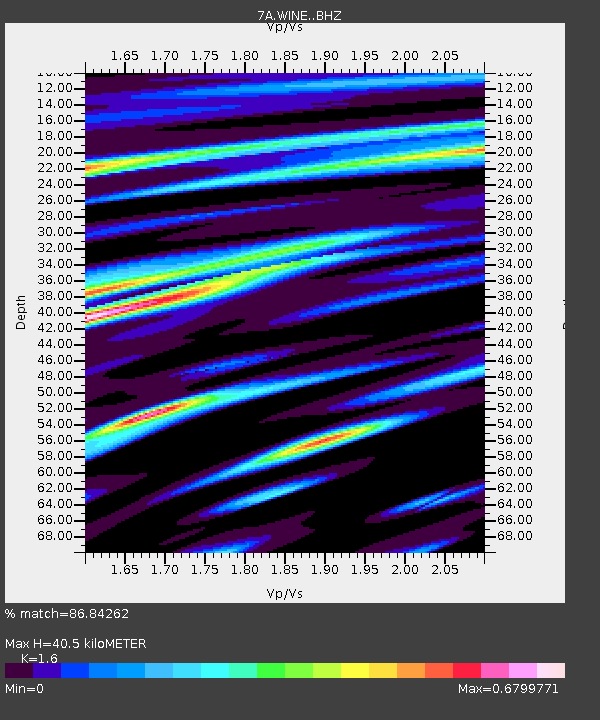
| Estimated Moho Depth: |
40.5 km |
| Estimated Crust Vp/Vs: |
1.60 |
| Assumed Crust Vp: |
6.159 km/s |
| Estimated Crust Vs: |
3.849 km/s |
| Estimated Crust Poisson's Ratio: |
0.18 |
|
| Radial Match: |
86.84262 % |
| Radial Bump: |
316 |
| Transverse Match: |
67.947334 % |
| Transverse Bump: |
400 |
| SOD ConfigId: |
7019011 |
| Insert Time: |
2019-04-17 00:49:08.234 +0000 |
| GWidth: |
2.5 |
| Max Bumps: |
400 |
| Tol: |
0.001 |
|

Signal To Noise
| Channel | StoN | STA | LTA |
| 7A:WINE: :BHZ:20150222T14:29:06.409998Z | 6.516583 | 1.5596916E-6 | 2.3934192E-7 |
| 7A:WINE: :BHN:20150222T14:29:06.409998Z | 3.155158 | 5.131153E-7 | 1.6262746E-7 |
| 7A:WINE: :BHE:20150222T14:29:06.409998Z | 2.8041224 | 7.9657093E-7 | 2.8407138E-7 |
| Arrivals |
| Ps | 4.3 SECOND |
| PpPs | 16 SECOND |
| PsPs/PpSs | 20 SECOND |


