You are here: Home > Network List > N4 - Central and EAstern US Network Stations List
> Station J47A Sunmer, MI, USA > Earthquake Result Viewer
J47A Sunmer, MI, USA - Earthquake Result Viewer
| Earthquake location: |
Off Coast Of Jalisco, Mexico |
| Earthquake latitude/longitude: |
18.7/-106.8 |
| Earthquake time(UTC): |
2015/02/22 (053) 14:23:14 GMT |
| Earthquake Depth: |
10 km |
| Earthquake Magnitude: |
6.2 MO |
| Earthquake Catalog/Contributor: |
NEIC PDE/NEIC ALERT |
|
| Network: |
N4 Central and EAstern US Network |
| Station: |
J47A Sunmer, MI, USA |
| Lat/Lon: |
43.24 N/84.82 W |
| Elevation: |
236 m |
|
| Distance: |
30.7 deg |
| Az: |
32.419 deg |
| Baz: |
224.048 deg |
| Ray Param: |
0.07926719 |
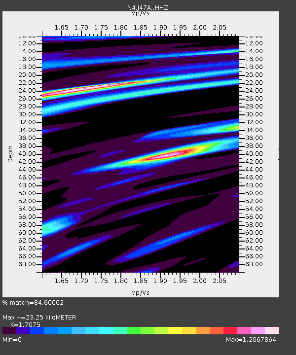
| Estimated Moho Depth: |
23.25 km |
| Estimated Crust Vp/Vs: |
1.71 |
| Assumed Crust Vp: |
6.483 km/s |
| Estimated Crust Vs: |
3.797 km/s |
| Estimated Crust Poisson's Ratio: |
0.24 |
|
| Radial Match: |
84.60002 % |
| Radial Bump: |
274 |
| Transverse Match: |
54.471535 % |
| Transverse Bump: |
353 |
| SOD ConfigId: |
7019011 |
| Insert Time: |
2019-04-17 00:52:02.453 +0000 |
| GWidth: |
2.5 |
| Max Bumps: |
400 |
| Tol: |
0.001 |
|

Signal To Noise
| Channel | StoN | STA | LTA |
| N4:J47A: :HHZ:20150222T14:28:59.520013Z | 4.996357 | 1.4360647E-6 | 2.8742235E-7 |
| N4:J47A: :HHN:20150222T14:28:59.520013Z | 2.4528096 | 6.8292866E-7 | 2.784271E-7 |
| N4:J47A: :HHE:20150222T14:28:59.520013Z | 1.9197446 | 5.8147657E-7 | 3.0289266E-7 |
| Arrivals |
| Ps | 2.8 SECOND |
| PpPs | 8.9 SECOND |
| PsPs/PpSs | 12 SECOND |


