You are here: Home > Network List > N4 - Central and EAstern US Network Stations List
> Station N51A Ashland, OH, USA > Earthquake Result Viewer
N51A Ashland, OH, USA - Earthquake Result Viewer
| Earthquake location: |
Off Coast Of Jalisco, Mexico |
| Earthquake latitude/longitude: |
18.7/-106.8 |
| Earthquake time(UTC): |
2015/02/22 (053) 14:23:14 GMT |
| Earthquake Depth: |
10 km |
| Earthquake Magnitude: |
6.2 MO |
| Earthquake Catalog/Contributor: |
NEIC PDE/NEIC ALERT |
|
| Network: |
N4 Central and EAstern US Network |
| Station: |
N51A Ashland, OH, USA |
| Lat/Lon: |
40.92 N/82.37 W |
| Elevation: |
343 m |
|
| Distance: |
30.5 deg |
| Az: |
38.199 deg |
| Baz: |
230.661 deg |
| Ray Param: |
0.0793278 |
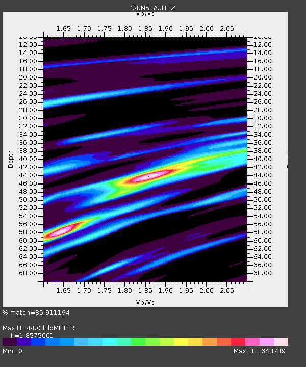
| Estimated Moho Depth: |
44.0 km |
| Estimated Crust Vp/Vs: |
1.86 |
| Assumed Crust Vp: |
6.498 km/s |
| Estimated Crust Vs: |
3.498 km/s |
| Estimated Crust Poisson's Ratio: |
0.30 |
|
| Radial Match: |
85.911194 % |
| Radial Bump: |
226 |
| Transverse Match: |
61.218407 % |
| Transverse Bump: |
396 |
| SOD ConfigId: |
7019011 |
| Insert Time: |
2019-04-17 00:52:08.244 +0000 |
| GWidth: |
2.5 |
| Max Bumps: |
400 |
| Tol: |
0.001 |
|

Signal To Noise
| Channel | StoN | STA | LTA |
| N4:N51A: :HHZ:20150222T14:28:57.510004Z | 4.5508924 | 1.4255725E-6 | 3.132512E-7 |
| N4:N51A: :HHN:20150222T14:28:57.510004Z | 2.7740197 | 6.6863635E-7 | 2.410352E-7 |
| N4:N51A: :HHE:20150222T14:28:57.510004Z | 2.1676698 | 6.319379E-7 | 2.9152866E-7 |
| Arrivals |
| Ps | 6.3 SECOND |
| PpPs | 18 SECOND |
| PsPs/PpSs | 24 SECOND |


