You are here: Home > Network List > CI - Caltech Regional Seismic Network Stations List
> Station VCS Vincent Substation, Palmdale, CA, USA > Earthquake Result Viewer
VCS Vincent Substation, Palmdale, CA, USA - Earthquake Result Viewer

| Earthquake location: |
Near Coast Of Peru |
| Earthquake latitude/longitude: |
-16.3/-73.6 |
| Earthquake time(UTC): |
2001/06/23 (174) 20:33:14 GMT |
| Earthquake Depth: |
33 km |
| Earthquake Magnitude: |
6.7 MB, 8.2 MS, 8.4 MW, 7.8 ME |
| Earthquake Catalog/Contributor: |
WHDF/NEIC |
|
| Network: |
CI Caltech Regional Seismic Network |
| Station: |
VCS Vincent Substation, Palmdale, CA, USA |
| Lat/Lon: |
34.48 N/118.12 W |
| Elevation: |
991 m |
|
| Distance: |
65.8 deg |
| Az: |
320.632 deg |
| Baz: |
132.479 deg |
| Ray Param: |
0.057953667 |
| Estimated Moho Depth: |
23.5 km |
| Estimated Crust Vp/Vs: |
1.99 |
| Assumed Crust Vp: |
6.1 km/s |
| Estimated Crust Vs: |
3.065 km/s |
| Estimated Crust Poisson's Ratio: |
0.33 |
|
| Radial Match: |
97.16369 % |
| Radial Bump: |
235 |
| Transverse Match: |
72.70206 % |
| Transverse Bump: |
400 |
| SOD ConfigId: |
3787 |
| Insert Time: |
2010-02-25 21:04:38.901 +0000 |
| GWidth: |
2.5 |
| Max Bumps: |
400 |
| Tol: |
0.001 |
|
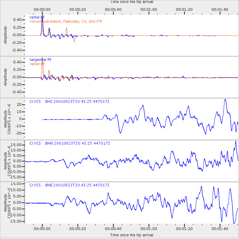
Signal To Noise
| Channel | StoN | STA | LTA |
| CI:VCS: :BHN:20010623T20:43:25.447017Z | 1.9349755 | 3.9667515E-7 | 2.0500266E-7 |
| CI:VCS: :BHE:20010623T20:43:25.447017Z | 1.6506305 | 2.878034E-7 | 1.7435968E-7 |
| CI:VCS: :BHZ:20010623T20:43:25.447017Z | 8.768634 | 1.2736377E-6 | 1.4524929E-7 |
| Arrivals |
| Ps | 3.9 SECOND |
| PpPs | 11 SECOND |
| PsPs/PpSs | 15 SECOND |


