You are here: Home > Network List > TA - USArray Transportable Network (new EarthScope stations) Stations List
> Station M52A Chesterland, OH, USA > Earthquake Result Viewer
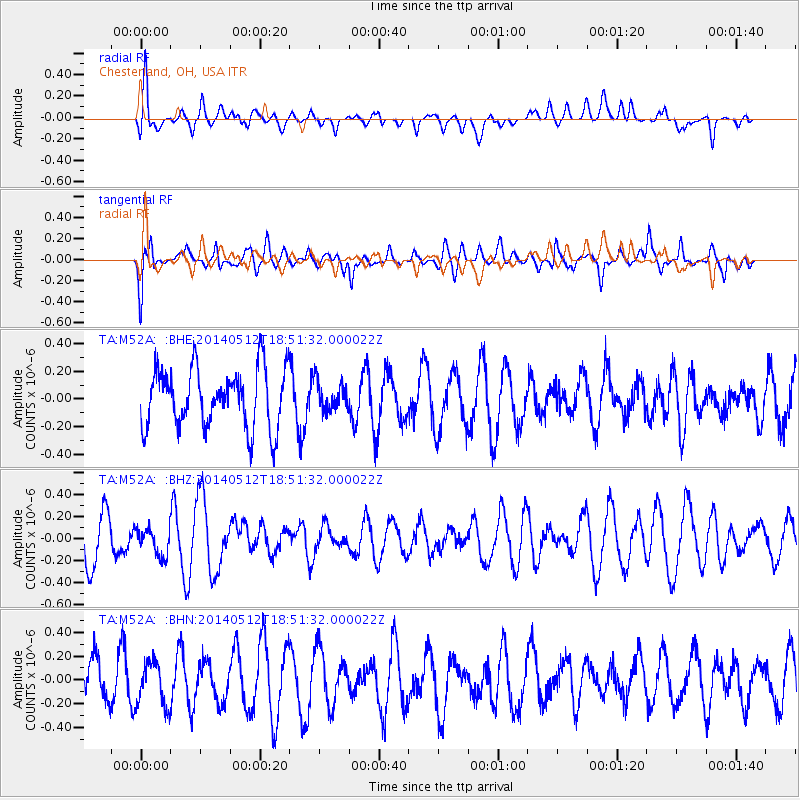
M52A Chesterland, OH, USA - Earthquake Result Viewer
*The percent match for this event was below the threshold and hence no stack was calculated.
| Earthquake location: |
Southern East Pacific Rise |
| Earthquake latitude/longitude: |
-50.0/-114.7 |
| Earthquake time(UTC): |
2014/05/12 (132) 18:38:37 GMT |
| Earthquake Depth: |
8.2 km |
| Earthquake Magnitude: |
5.8 MB |
| Earthquake Catalog/Contributor: |
NEIC PDE/NEIC COMCAT |
|
| Network: |
TA USArray Transportable Network (new EarthScope stations) |
| Station: |
M52A Chesterland, OH, USA |
| Lat/Lon: |
41.54 N/81.36 W |
| Elevation: |
382 m |
|
| Distance: |
95.7 deg |
| Az: |
24.477 deg |
| Baz: |
200.88 deg |
| Ray Param: |
$rayparam |
*The percent match for this event was below the threshold and hence was not used in the summary stack. |
|
| Radial Match: |
57.952156 % |
| Radial Bump: |
400 |
| Transverse Match: |
60.875343 % |
| Transverse Bump: |
400 |
| SOD ConfigId: |
626651 |
| Insert Time: |
2014-05-26 19:16:12.755 +0000 |
| GWidth: |
2.5 |
| Max Bumps: |
400 |
| Tol: |
0.001 |
|
Signal To Noise
| Channel | StoN | STA | LTA |
| TA:M52A: :BHZ:20140512T18:51:32.000022Z | 0.7442793 | 1.265741E-7 | 1.7006263E-7 |
| TA:M52A: :BHN:20140512T18:51:32.000022Z | 1.21132 | 1.8025955E-7 | 1.4881248E-7 |
| TA:M52A: :BHE:20140512T18:51:32.000022Z | 0.48579767 | 1.0287124E-7 | 2.1175738E-7 |
| Arrivals |
| Ps | |
| PpPs | |
| PsPs/PpSs | |


