You are here: Home > Network List > TA - USArray Transportable Network (new EarthScope stations) Stations List
> Station O03E Paynes Creek, CA, USA > Earthquake Result Viewer
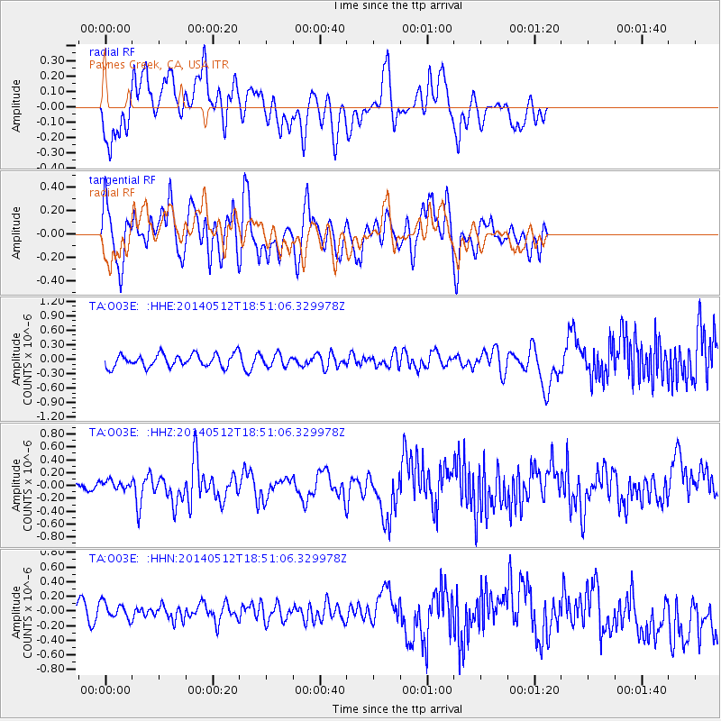
O03E Paynes Creek, CA, USA - Earthquake Result Viewer
*The percent match for this event was below the threshold and hence no stack was calculated.
| Earthquake location: |
Southern East Pacific Rise |
| Earthquake latitude/longitude: |
-50.0/-114.7 |
| Earthquake time(UTC): |
2014/05/12 (132) 18:38:37 GMT |
| Earthquake Depth: |
8.2 km |
| Earthquake Magnitude: |
5.8 MB |
| Earthquake Catalog/Contributor: |
NEIC PDE/NEIC COMCAT |
|
| Network: |
TA USArray Transportable Network (new EarthScope stations) |
| Station: |
O03E Paynes Creek, CA, USA |
| Lat/Lon: |
40.29 N/121.80 W |
| Elevation: |
967 m |
|
| Distance: |
90.1 deg |
| Az: |
354.55 deg |
| Baz: |
175.401 deg |
| Ray Param: |
$rayparam |
*The percent match for this event was below the threshold and hence was not used in the summary stack. |
|
| Radial Match: |
69.88669 % |
| Radial Bump: |
400 |
| Transverse Match: |
62.526337 % |
| Transverse Bump: |
400 |
| SOD ConfigId: |
626651 |
| Insert Time: |
2014-05-26 19:16:40.032 +0000 |
| GWidth: |
2.5 |
| Max Bumps: |
400 |
| Tol: |
0.001 |
|
Signal To Noise
| Channel | StoN | STA | LTA |
| TA:O03E: :HHZ:20140512T18:51:06.329978Z | 1.0539081 | 7.532864E-8 | 7.1475526E-8 |
| TA:O03E: :HHN:20140512T18:51:06.329978Z | 1.0917025 | 1.2609496E-7 | 1.1550304E-7 |
| TA:O03E: :HHE:20140512T18:51:06.329978Z | 0.9287144 | 1.221127E-7 | 1.3148573E-7 |
| Arrivals |
| Ps | |
| PpPs | |
| PsPs/PpSs | |


