You are here: Home > Network List > TA - USArray Transportable Network (new EarthScope stations) Stations List
> Station U57A Blanch, NC, USA > Earthquake Result Viewer
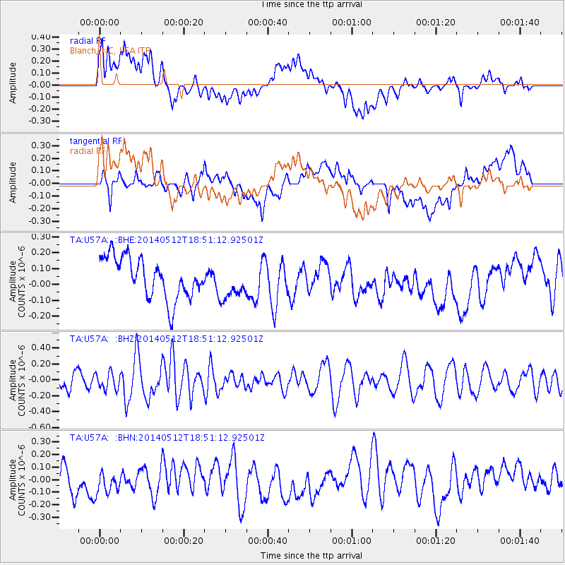
U57A Blanch, NC, USA - Earthquake Result Viewer
*The percent match for this event was below the threshold and hence no stack was calculated.
| Earthquake location: |
Southern East Pacific Rise |
| Earthquake latitude/longitude: |
-50.0/-114.7 |
| Earthquake time(UTC): |
2014/05/12 (132) 18:38:37 GMT |
| Earthquake Depth: |
8.2 km |
| Earthquake Magnitude: |
5.8 MB |
| Earthquake Catalog/Contributor: |
NEIC PDE/NEIC COMCAT |
|
| Network: |
TA USArray Transportable Network (new EarthScope stations) |
| Station: |
U57A Blanch, NC, USA |
| Lat/Lon: |
36.43 N/79.34 W |
| Elevation: |
178 m |
|
| Distance: |
91.5 deg |
| Az: |
27.812 deg |
| Baz: |
201.937 deg |
| Ray Param: |
$rayparam |
*The percent match for this event was below the threshold and hence was not used in the summary stack. |
|
| Radial Match: |
50.289806 % |
| Radial Bump: |
400 |
| Transverse Match: |
52.006516 % |
| Transverse Bump: |
400 |
| SOD ConfigId: |
626651 |
| Insert Time: |
2014-05-26 19:17:46.129 +0000 |
| GWidth: |
2.5 |
| Max Bumps: |
400 |
| Tol: |
0.001 |
|
Signal To Noise
| Channel | StoN | STA | LTA |
| TA:U57A: :BHZ:20140512T18:51:12.92501Z | 0.9401356 | 1.0439104E-7 | 1.1103828E-7 |
| TA:U57A: :BHN:20140512T18:51:12.92501Z | 0.8518791 | 1.398895E-7 | 1.6421284E-7 |
| TA:U57A: :BHE:20140512T18:51:12.92501Z | 0.8235407 | 1.051625E-7 | 1.2769557E-7 |
| Arrivals |
| Ps | |
| PpPs | |
| PsPs/PpSs | |


