You are here: Home > Network List > RV - Regional Alberta Seismic Observatory for Earthquake Studies Network Stations List
> Station WAPA Wapiti River, AB > Earthquake Result Viewer
WAPA Wapiti River, AB - Earthquake Result Viewer
| Earthquake location: |
Off Coast Of Jalisco, Mexico |
| Earthquake latitude/longitude: |
18.7/-106.8 |
| Earthquake time(UTC): |
2015/02/22 (053) 14:23:14 GMT |
| Earthquake Depth: |
10 km |
| Earthquake Magnitude: |
6.2 MO |
| Earthquake Catalog/Contributor: |
NEIC PDE/NEIC ALERT |
|
| Network: |
RV Regional Alberta Seismic Observatory for Earthquake Studies Network |
| Station: |
WAPA Wapiti River, AB |
| Lat/Lon: |
55.18 N/119.25 W |
| Elevation: |
784 m |
|
| Distance: |
37.6 deg |
| Az: |
348.315 deg |
| Baz: |
160.447 deg |
| Ray Param: |
0.07603672 |
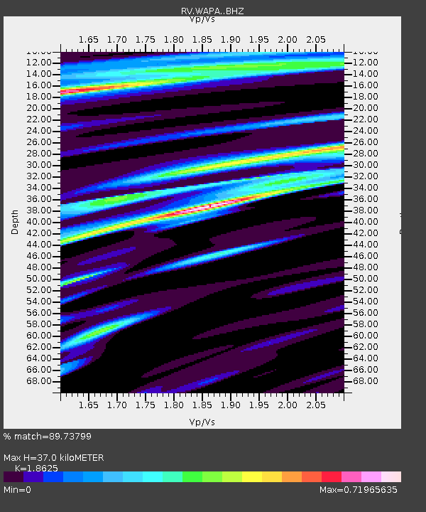
| Estimated Moho Depth: |
37.0 km |
| Estimated Crust Vp/Vs: |
1.86 |
| Assumed Crust Vp: |
6.161 km/s |
| Estimated Crust Vs: |
3.308 km/s |
| Estimated Crust Poisson's Ratio: |
0.30 |
|
| Radial Match: |
89.73799 % |
| Radial Bump: |
311 |
| Transverse Match: |
78.14881 % |
| Transverse Bump: |
400 |
| SOD ConfigId: |
7019011 |
| Insert Time: |
2019-04-17 00:53:05.642 +0000 |
| GWidth: |
2.5 |
| Max Bumps: |
400 |
| Tol: |
0.001 |
|

Signal To Noise
| Channel | StoN | STA | LTA |
| RV:WAPA: :BHZ:20150222T14:29:58.774988Z | 5.0304036 | 8.8903516E-7 | 1.7673237E-7 |
| RV:WAPA: :BHN:20150222T14:29:58.774988Z | 2.0171702 | 4.7802934E-7 | 2.3698017E-7 |
| RV:WAPA: :BHE:20150222T14:29:58.774988Z | 0.70239943 | 2.610092E-7 | 3.7159657E-7 |
| Arrivals |
| Ps | 5.5 SECOND |
| PpPs | 16 SECOND |
| PsPs/PpSs | 22 SECOND |


