You are here: Home > Network List > US - United States National Seismic Network Stations List
> Station MNTX Cornudas Mountains, Texas, USA > Earthquake Result Viewer
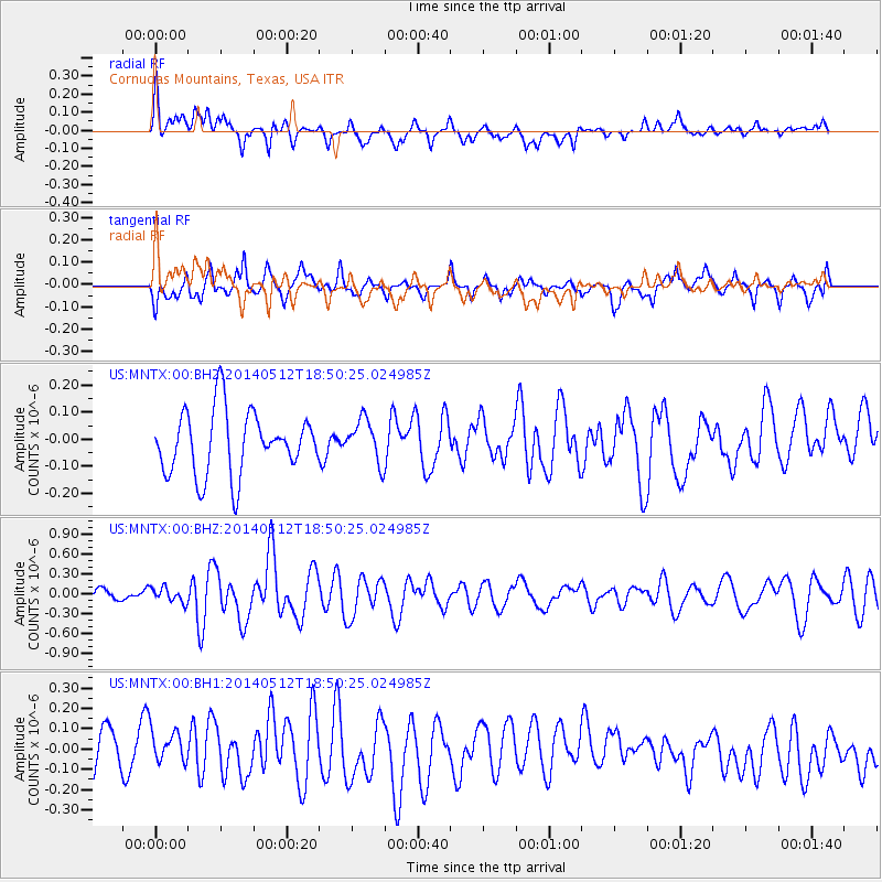
MNTX Cornudas Mountains, Texas, USA - Earthquake Result Viewer
*The percent match for this event was below the threshold and hence no stack was calculated.
| Earthquake location: |
Southern East Pacific Rise |
| Earthquake latitude/longitude: |
-50.0/-114.7 |
| Earthquake time(UTC): |
2014/05/12 (132) 18:38:37 GMT |
| Earthquake Depth: |
8.2 km |
| Earthquake Magnitude: |
5.8 MB |
| Earthquake Catalog/Contributor: |
NEIC PDE/NEIC COMCAT |
|
| Network: |
US United States National Seismic Network |
| Station: |
MNTX Cornudas Mountains, Texas, USA |
| Lat/Lon: |
31.70 N/105.38 W |
| Elevation: |
404 m |
|
| Distance: |
81.7 deg |
| Az: |
7.991 deg |
| Baz: |
186.045 deg |
| Ray Param: |
$rayparam |
*The percent match for this event was below the threshold and hence was not used in the summary stack. |
|
| Radial Match: |
66.952576 % |
| Radial Bump: |
400 |
| Transverse Match: |
57.28057 % |
| Transverse Bump: |
400 |
| SOD ConfigId: |
626651 |
| Insert Time: |
2014-05-26 19:20:24.379 +0000 |
| GWidth: |
2.5 |
| Max Bumps: |
400 |
| Tol: |
0.001 |
|
Signal To Noise
| Channel | StoN | STA | LTA |
| US:MNTX:00:BHZ:20140512T18:50:25.024985Z | 0.8001424 | 1.1055848E-7 | 1.381735E-7 |
| US:MNTX:00:BH1:20140512T18:50:25.024985Z | 1.1807292 | 9.769888E-8 | 8.2744535E-8 |
| US:MNTX:00:BH2:20140512T18:50:25.024985Z | 0.6822174 | 7.952552E-8 | 1.16569176E-7 |
| Arrivals |
| Ps | |
| PpPs | |
| PsPs/PpSs | |


