You are here: Home > Network List > TA - USArray Transportable Network (new EarthScope stations) Stations List
> Station D58A Chemin du LacGrosbois, Trois-Rives, QC, CAN > Earthquake Result Viewer
D58A Chemin du LacGrosbois, Trois-Rives, QC, CAN - Earthquake Result Viewer
| Earthquake location: |
Off Coast Of Jalisco, Mexico |
| Earthquake latitude/longitude: |
18.7/-106.8 |
| Earthquake time(UTC): |
2015/02/22 (053) 14:23:14 GMT |
| Earthquake Depth: |
10 km |
| Earthquake Magnitude: |
6.2 MO |
| Earthquake Catalog/Contributor: |
NEIC PDE/NEIC ALERT |
|
| Network: |
TA USArray Transportable Network (new EarthScope stations) |
| Station: |
D58A Chemin du LacGrosbois, Trois-Rives, QC, CAN |
| Lat/Lon: |
47.10 N/72.88 W |
| Elevation: |
398 m |
|
| Distance: |
39.6 deg |
| Az: |
36.717 deg |
| Baz: |
236.032 deg |
| Ray Param: |
0.07487587 |
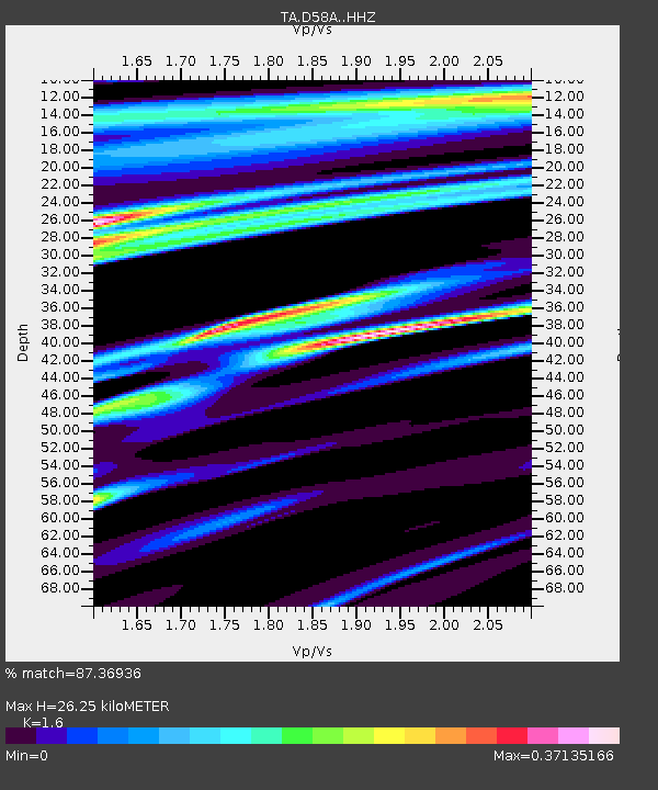
| Estimated Moho Depth: |
26.25 km |
| Estimated Crust Vp/Vs: |
1.60 |
| Assumed Crust Vp: |
6.61 km/s |
| Estimated Crust Vs: |
4.131 km/s |
| Estimated Crust Poisson's Ratio: |
0.18 |
|
| Radial Match: |
87.36936 % |
| Radial Bump: |
208 |
| Transverse Match: |
61.201485 % |
| Transverse Bump: |
400 |
| SOD ConfigId: |
7019011 |
| Insert Time: |
2019-04-17 00:53:17.198 +0000 |
| GWidth: |
2.5 |
| Max Bumps: |
400 |
| Tol: |
0.001 |
|
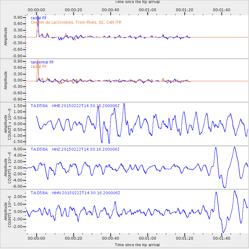
Signal To Noise
| Channel | StoN | STA | LTA |
| TA:D58A: :HHZ:20150222T14:30:16.200006Z | 2.181567 | 1.057999E-6 | 4.849721E-7 |
| TA:D58A: :HHN:20150222T14:30:16.200006Z | 1.2080069 | 3.043213E-7 | 2.5192017E-7 |
| TA:D58A: :HHE:20150222T14:30:16.200006Z | 2.3020198 | 6.3602715E-7 | 2.762909E-7 |
| Arrivals |
| Ps | 2.6 SECOND |
| PpPs | 9.5 SECOND |
| PsPs/PpSs | 12 SECOND |


