You are here: Home > Network List > TA - USArray Transportable Network (new EarthScope stations) Stations List
> Station F64A Sherman, ME, USA > Earthquake Result Viewer
F64A Sherman, ME, USA - Earthquake Result Viewer
| Earthquake location: |
Off Coast Of Jalisco, Mexico |
| Earthquake latitude/longitude: |
18.7/-106.8 |
| Earthquake time(UTC): |
2015/02/22 (053) 14:23:14 GMT |
| Earthquake Depth: |
10 km |
| Earthquake Magnitude: |
6.2 MO |
| Earthquake Catalog/Contributor: |
NEIC PDE/NEIC ALERT |
|
| Network: |
TA USArray Transportable Network (new EarthScope stations) |
| Station: |
F64A Sherman, ME, USA |
| Lat/Lon: |
45.86 N/68.35 W |
| Elevation: |
179 m |
|
| Distance: |
41.7 deg |
| Az: |
40.802 deg |
| Baz: |
242.41 deg |
| Ray Param: |
0.073634684 |
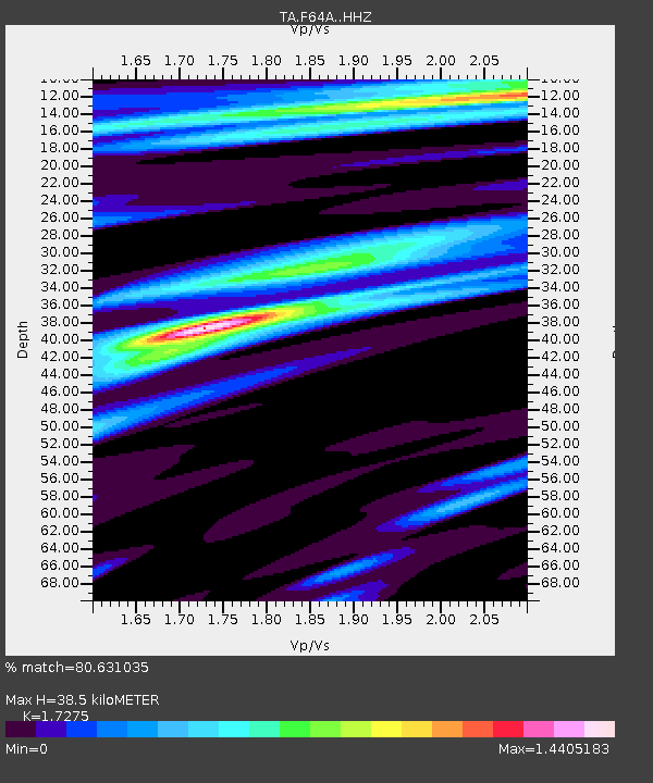
| Estimated Moho Depth: |
38.5 km |
| Estimated Crust Vp/Vs: |
1.73 |
| Assumed Crust Vp: |
6.419 km/s |
| Estimated Crust Vs: |
3.716 km/s |
| Estimated Crust Poisson's Ratio: |
0.25 |
|
| Radial Match: |
80.631035 % |
| Radial Bump: |
230 |
| Transverse Match: |
44.539146 % |
| Transverse Bump: |
275 |
| SOD ConfigId: |
7019011 |
| Insert Time: |
2019-04-17 00:53:30.688 +0000 |
| GWidth: |
2.5 |
| Max Bumps: |
400 |
| Tol: |
0.001 |
|

Signal To Noise
| Channel | StoN | STA | LTA |
| TA:F64A: :HHZ:20150222T14:30:33.179987Z | 1.951615 | 9.366857E-7 | 4.7995417E-7 |
| TA:F64A: :HHN:20150222T14:30:33.179987Z | 1.1288341 | 4.739643E-7 | 4.1987062E-7 |
| TA:F64A: :HHE:20150222T14:30:33.179987Z | 1.7700667 | 7.0909874E-7 | 4.0060567E-7 |
| Arrivals |
| Ps | 4.7 SECOND |
| PpPs | 15 SECOND |
| PsPs/PpSs | 20 SECOND |


