You are here: Home > Network List > TA - USArray Transportable Network (new EarthScope stations) Stations List
> Station G65A Princeton, ME, USA > Earthquake Result Viewer
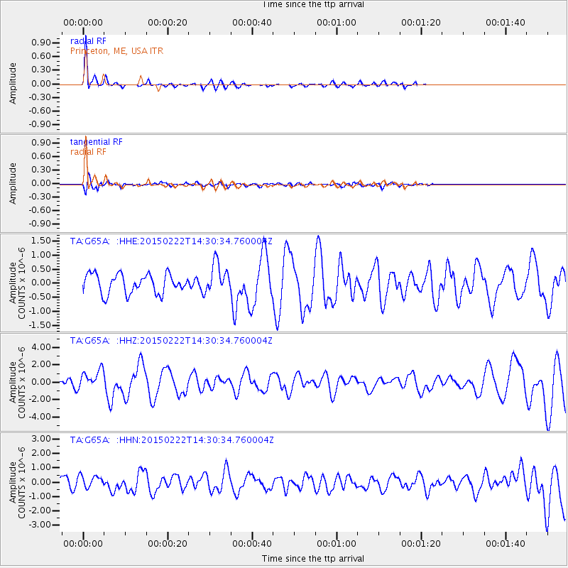
G65A Princeton, ME, USA - Earthquake Result Viewer
*The percent match for this event was below the threshold and hence no stack was calculated.
| Earthquake location: |
Off Coast Of Jalisco, Mexico |
| Earthquake latitude/longitude: |
18.7/-106.8 |
| Earthquake time(UTC): |
2015/02/22 (053) 14:23:14 GMT |
| Earthquake Depth: |
10 km |
| Earthquake Magnitude: |
6.2 MO |
| Earthquake Catalog/Contributor: |
NEIC PDE/NEIC ALERT |
|
| Network: |
TA USArray Transportable Network (new EarthScope stations) |
| Station: |
G65A Princeton, ME, USA |
| Lat/Lon: |
45.20 N/67.56 W |
| Elevation: |
78 m |
|
| Distance: |
41.9 deg |
| Az: |
42.064 deg |
| Baz: |
243.911 deg |
| Ray Param: |
$rayparam |
*The percent match for this event was below the threshold and hence was not used in the summary stack. |
|
| Radial Match: |
79.1015 % |
| Radial Bump: |
331 |
| Transverse Match: |
57.059223 % |
| Transverse Bump: |
400 |
| SOD ConfigId: |
7019011 |
| Insert Time: |
2019-04-17 00:53:37.413 +0000 |
| GWidth: |
2.5 |
| Max Bumps: |
400 |
| Tol: |
0.001 |
|
Signal To Noise
| Channel | StoN | STA | LTA |
| TA:G65A: :HHZ:20150222T14:30:34.760004Z | 1.7725935 | 1.1270786E-6 | 6.358359E-7 |
| TA:G65A: :HHN:20150222T14:30:34.760004Z | 1.3778832 | 4.5626152E-7 | 3.3113224E-7 |
| TA:G65A: :HHE:20150222T14:30:34.760004Z | 1.6027987 | 5.5461476E-7 | 3.4602894E-7 |
| Arrivals |
| Ps | |
| PpPs | |
| PsPs/PpSs | |


