You are here: Home > Network List > TA - USArray Transportable Network (new EarthScope stations) Stations List
> Station H60A Morristown, VT, USA > Earthquake Result Viewer
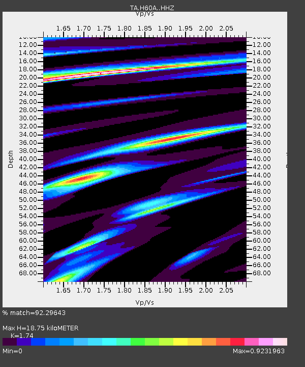
H60A Morristown, VT, USA - Earthquake Result Viewer
| Earthquake location: |
Off Coast Of Jalisco, Mexico |
| Earthquake latitude/longitude: |
18.7/-106.8 |
| Earthquake time(UTC): |
2015/02/22 (053) 14:23:14 GMT |
| Earthquake Depth: |
10 km |
| Earthquake Magnitude: |
6.2 MO |
| Earthquake Catalog/Contributor: |
NEIC PDE/NEIC ALERT |
|
| Network: |
TA USArray Transportable Network (new EarthScope stations) |
| Station: |
H60A Morristown, VT, USA |
| Lat/Lon: |
44.56 N/72.70 W |
| Elevation: |
459 m |
|
| Distance: |
38.4 deg |
| Az: |
40.224 deg |
| Baz: |
238.89 deg |
| Ray Param: |
0.07560116 |
| Estimated Moho Depth: |
18.75 km |
| Estimated Crust Vp/Vs: |
1.74 |
| Assumed Crust Vp: |
6.419 km/s |
| Estimated Crust Vs: |
3.689 km/s |
| Estimated Crust Poisson's Ratio: |
0.25 |
|
| Radial Match: |
92.29643 % |
| Radial Bump: |
196 |
| Transverse Match: |
76.036095 % |
| Transverse Bump: |
400 |
| SOD ConfigId: |
7019011 |
| Insert Time: |
2019-04-17 00:53:39.808 +0000 |
| GWidth: |
2.5 |
| Max Bumps: |
400 |
| Tol: |
0.001 |
|

Signal To Noise
| Channel | StoN | STA | LTA |
| TA:H60A: :HHZ:20150222T14:30:05.719995Z | 3.0488772 | 1.0206821E-6 | 3.3477312E-7 |
| TA:H60A: :HHN:20150222T14:30:05.719995Z | 2.069646 | 8.1986406E-7 | 3.9613732E-7 |
| TA:H60A: :HHE:20150222T14:30:05.719995Z | 1.7430667 | 6.1003715E-7 | 3.4997925E-7 |
| Arrivals |
| Ps | 2.3 SECOND |
| PpPs | 7.4 SECOND |
| PsPs/PpSs | 9.8 SECOND |


