You are here: Home > Network List > TA - USArray Transportable Network (new EarthScope stations) Stations List
> Station I60A Shoreham, VT, USA > Earthquake Result Viewer
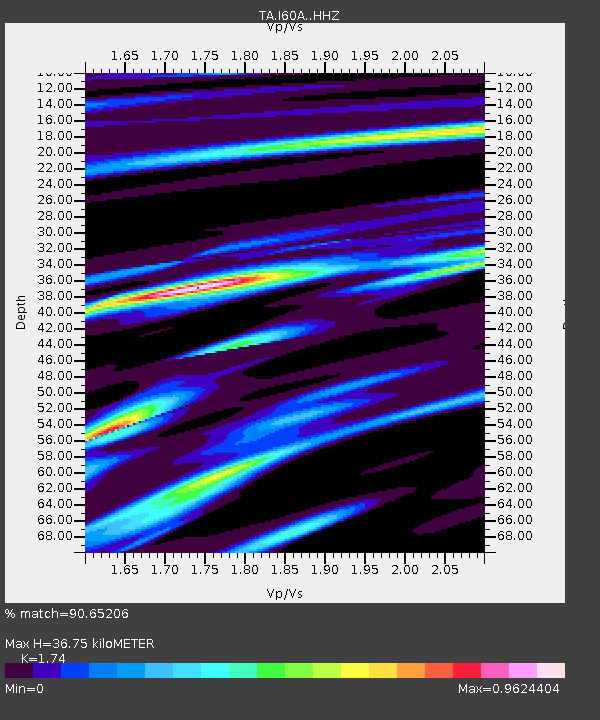
I60A Shoreham, VT, USA - Earthquake Result Viewer
| Earthquake location: |
Off Coast Of Jalisco, Mexico |
| Earthquake latitude/longitude: |
18.7/-106.8 |
| Earthquake time(UTC): |
2015/02/22 (053) 14:23:14 GMT |
| Earthquake Depth: |
10 km |
| Earthquake Magnitude: |
6.2 MO |
| Earthquake Catalog/Contributor: |
NEIC PDE/NEIC ALERT |
|
| Network: |
TA USArray Transportable Network (new EarthScope stations) |
| Station: |
I60A Shoreham, VT, USA |
| Lat/Lon: |
43.84 N/73.29 W |
| Elevation: |
101 m |
|
| Distance: |
37.6 deg |
| Az: |
40.863 deg |
| Baz: |
238.981 deg |
| Ray Param: |
0.07602724 |
| Estimated Moho Depth: |
36.75 km |
| Estimated Crust Vp/Vs: |
1.74 |
| Assumed Crust Vp: |
6.419 km/s |
| Estimated Crust Vs: |
3.689 km/s |
| Estimated Crust Poisson's Ratio: |
0.25 |
|
| Radial Match: |
90.65206 % |
| Radial Bump: |
223 |
| Transverse Match: |
76.68882 % |
| Transverse Bump: |
389 |
| SOD ConfigId: |
7019011 |
| Insert Time: |
2019-04-17 00:53:45.299 +0000 |
| GWidth: |
2.5 |
| Max Bumps: |
400 |
| Tol: |
0.001 |
|

Signal To Noise
| Channel | StoN | STA | LTA |
| TA:I60A: :HHZ:20150222T14:29:59.540002Z | 2.4903371 | 1.0903381E-6 | 4.378275E-7 |
| TA:I60A: :HHN:20150222T14:29:59.540002Z | 1.9815757 | 5.2397854E-7 | 2.6442518E-7 |
| TA:I60A: :HHE:20150222T14:29:59.540002Z | 2.7290785 | 6.4191465E-7 | 2.3521297E-7 |
| Arrivals |
| Ps | 4.6 SECOND |
| PpPs | 15 SECOND |
| PsPs/PpSs | 19 SECOND |


