You are here: Home > Network List > TA - USArray Transportable Network (new EarthScope stations) Stations List
> Station L56A Greenwood, NY, USA > Earthquake Result Viewer
L56A Greenwood, NY, USA - Earthquake Result Viewer
| Earthquake location: |
Off Coast Of Jalisco, Mexico |
| Earthquake latitude/longitude: |
18.7/-106.8 |
| Earthquake time(UTC): |
2015/02/22 (053) 14:23:14 GMT |
| Earthquake Depth: |
10 km |
| Earthquake Magnitude: |
6.2 MO |
| Earthquake Catalog/Contributor: |
NEIC PDE/NEIC ALERT |
|
| Network: |
TA USArray Transportable Network (new EarthScope stations) |
| Station: |
L56A Greenwood, NY, USA |
| Lat/Lon: |
42.14 N/77.56 W |
| Elevation: |
688 m |
|
| Distance: |
34.1 deg |
| Az: |
40.432 deg |
| Baz: |
235.731 deg |
| Ray Param: |
0.07791268 |
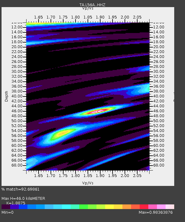
| Estimated Moho Depth: |
46.0 km |
| Estimated Crust Vp/Vs: |
1.89 |
| Assumed Crust Vp: |
6.476 km/s |
| Estimated Crust Vs: |
3.431 km/s |
| Estimated Crust Poisson's Ratio: |
0.30 |
|
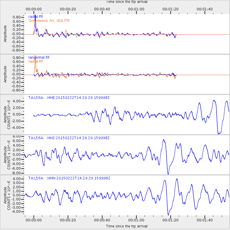
| Radial Match: |
92.69861 % |
| Radial Bump: |
309 |
| Transverse Match: |
60.401638 % |
| Transverse Bump: |
400 |
| SOD ConfigId: |
7019011 |
| Insert Time: |
2019-04-17 00:53:58.872 +0000 |
| GWidth: |
2.5 |
| Max Bumps: |
400 |
| Tol: |
0.001 |
|
Signal To Noise
| Channel | StoN | STA | LTA |
| TA:L56A: :HHZ:20150222T14:29:29.159998Z | 1.8808339 | 1.1588368E-6 | 6.161292E-7 |
| TA:L56A: :HHN:20150222T14:29:29.159998Z | 1.6199875 | 5.359517E-7 | 3.3083694E-7 |
| TA:L56A: :HHE:20150222T14:29:29.159998Z | 2.4369676 | 4.4869145E-7 | 1.8411876E-7 |
| Arrivals |
| Ps | 6.8 SECOND |
| PpPs | 19 SECOND |
| PsPs/PpSs | 26 SECOND |


