You are here: Home > Network List > TA - USArray Transportable Network (new EarthScope stations) Stations List
> Station L61B Northampton, MA, USA > Earthquake Result Viewer
L61B Northampton, MA, USA - Earthquake Result Viewer
| Earthquake location: |
Off Coast Of Jalisco, Mexico |
| Earthquake latitude/longitude: |
18.7/-106.8 |
| Earthquake time(UTC): |
2015/02/22 (053) 14:23:14 GMT |
| Earthquake Depth: |
10 km |
| Earthquake Magnitude: |
6.2 MO |
| Earthquake Catalog/Contributor: |
NEIC PDE/NEIC ALERT |
|
| Network: |
TA USArray Transportable Network (new EarthScope stations) |
| Station: |
L61B Northampton, MA, USA |
| Lat/Lon: |
42.45 N/72.68 W |
| Elevation: |
261 m |
|
| Distance: |
37.3 deg |
| Az: |
43.215 deg |
| Baz: |
241.265 deg |
| Ray Param: |
0.076195404 |
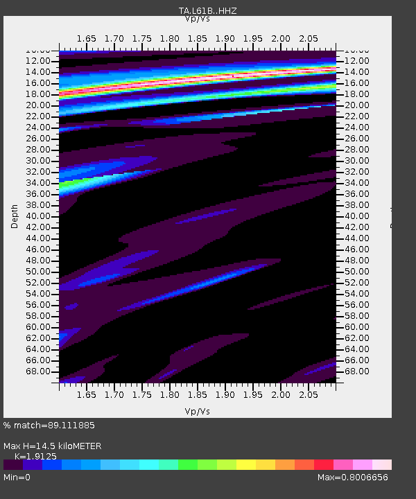
| Estimated Moho Depth: |
14.5 km |
| Estimated Crust Vp/Vs: |
1.91 |
| Assumed Crust Vp: |
6.419 km/s |
| Estimated Crust Vs: |
3.356 km/s |
| Estimated Crust Poisson's Ratio: |
0.31 |
|
| Radial Match: |
89.111885 % |
| Radial Bump: |
312 |
| Transverse Match: |
84.32954 % |
| Transverse Bump: |
400 |
| SOD ConfigId: |
7019011 |
| Insert Time: |
2019-04-17 00:54:03.344 +0000 |
| GWidth: |
2.5 |
| Max Bumps: |
400 |
| Tol: |
0.001 |
|

Signal To Noise
| Channel | StoN | STA | LTA |
| TA:L61B: :HHZ:20150222T14:29:56.950006Z | 2.239105 | 1.1670545E-6 | 5.2121476E-7 |
| TA:L61B: :HHN:20150222T14:29:56.950006Z | 1.644299 | 6.161249E-7 | 3.747037E-7 |
| TA:L61B: :HHE:20150222T14:29:56.950006Z | 2.9058826 | 6.804857E-7 | 2.3417522E-7 |
| Arrivals |
| Ps | 2.2 SECOND |
| PpPs | 6.1 SECOND |
| PsPs/PpSs | 8.4 SECOND |


