You are here: Home > Network List > TA - USArray Transportable Network (new EarthScope stations) Stations List
> Station O56A Blue Knob State Park, Imler, PA, USA > Earthquake Result Viewer
O56A Blue Knob State Park, Imler, PA, USA - Earthquake Result Viewer
| Earthquake location: |
Off Coast Of Jalisco, Mexico |
| Earthquake latitude/longitude: |
18.7/-106.8 |
| Earthquake time(UTC): |
2015/02/22 (053) 14:23:14 GMT |
| Earthquake Depth: |
10 km |
| Earthquake Magnitude: |
6.2 MO |
| Earthquake Catalog/Contributor: |
NEIC PDE/NEIC ALERT |
|
| Network: |
TA USArray Transportable Network (new EarthScope stations) |
| Station: |
O56A Blue Knob State Park, Imler, PA, USA |
| Lat/Lon: |
40.27 N/78.57 W |
| Elevation: |
684 m |
|
| Distance: |
32.4 deg |
| Az: |
42.493 deg |
| Baz: |
236.794 deg |
| Ray Param: |
0.078663856 |
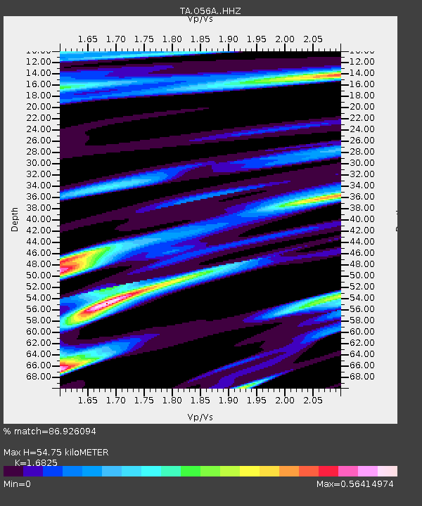
| Estimated Moho Depth: |
54.75 km |
| Estimated Crust Vp/Vs: |
1.68 |
| Assumed Crust Vp: |
6.121 km/s |
| Estimated Crust Vs: |
3.638 km/s |
| Estimated Crust Poisson's Ratio: |
0.23 |
|
| Radial Match: |
86.926094 % |
| Radial Bump: |
333 |
| Transverse Match: |
69.86112 % |
| Transverse Bump: |
281 |
| SOD ConfigId: |
7019011 |
| Insert Time: |
2019-04-17 00:54:19.856 +0000 |
| GWidth: |
2.5 |
| Max Bumps: |
400 |
| Tol: |
0.001 |
|

Signal To Noise
| Channel | StoN | STA | LTA |
| TA:O56A: :HHZ:20150222T14:29:14.659998Z | 2.741672 | 1.144808E-6 | 4.1755834E-7 |
| TA:O56A: :HHN:20150222T14:29:14.659998Z | 1.743818 | 3.9134397E-7 | 2.2441789E-7 |
| TA:O56A: :HHE:20150222T14:29:14.659998Z | 1.7632086 | 6.538423E-7 | 3.7082523E-7 |
| Arrivals |
| Ps | 6.6 SECOND |
| PpPs | 22 SECOND |
| PsPs/PpSs | 29 SECOND |


