You are here: Home > Network List > TA - USArray Transportable Network (new EarthScope stations) Stations List
> Station P57A Homestead Farm, Martinsburg, WV, USA > Earthquake Result Viewer
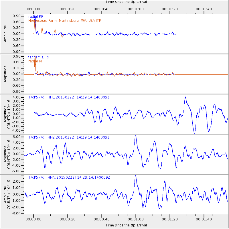
P57A Homestead Farm, Martinsburg, WV, USA - Earthquake Result Viewer
| Earthquake location: |
Off Coast Of Jalisco, Mexico |
| Earthquake latitude/longitude: |
18.7/-106.8 |
| Earthquake time(UTC): |
2015/02/22 (053) 14:23:14 GMT |
| Earthquake Depth: |
10 km |
| Earthquake Magnitude: |
6.2 MO |
| Earthquake Catalog/Contributor: |
NEIC PDE/NEIC ALERT |
|
| Network: |
TA USArray Transportable Network (new EarthScope stations) |
| Station: |
P57A Homestead Farm, Martinsburg, WV, USA |
| Lat/Lon: |
39.48 N/78.01 W |
| Elevation: |
191 m |
|
| Distance: |
32.4 deg |
| Az: |
44.156 deg |
| Baz: |
238.552 deg |
| Ray Param: |
0.07868899 |
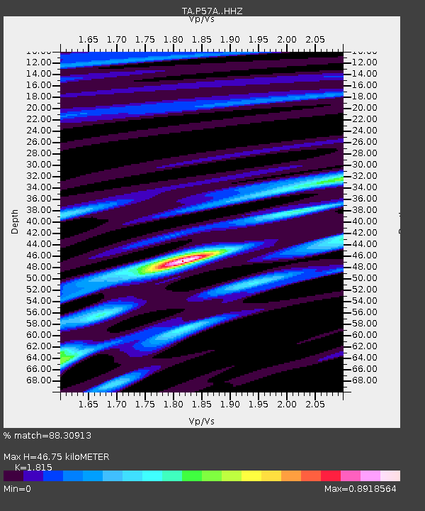
| Estimated Moho Depth: |
46.75 km |
| Estimated Crust Vp/Vs: |
1.82 |
| Assumed Crust Vp: |
6.159 km/s |
| Estimated Crust Vs: |
3.393 km/s |
| Estimated Crust Poisson's Ratio: |
0.28 |
|
| Radial Match: |
88.30913 % |
| Radial Bump: |
290 |
| Transverse Match: |
57.503155 % |
| Transverse Bump: |
400 |
| SOD ConfigId: |
7019011 |
| Insert Time: |
2019-04-17 00:54:25.768 +0000 |
| GWidth: |
2.5 |
| Max Bumps: |
400 |
| Tol: |
0.001 |
|
Signal To Noise
| Channel | StoN | STA | LTA |
| TA:P57A: :HHZ:20150222T14:29:14.140009Z | 3.291151 | 1.1885969E-6 | 3.611493E-7 |
| TA:P57A: :HHN:20150222T14:29:14.140009Z | 1.2812246 | 3.5237903E-7 | 2.75033E-7 |
| TA:P57A: :HHE:20150222T14:29:14.140009Z | 2.8605685 | 6.0860134E-7 | 2.1275538E-7 |
| Arrivals |
| Ps | 6.6 SECOND |
| PpPs | 20 SECOND |
| PsPs/PpSs | 27 SECOND |


