You are here: Home > Network List > AT - Alaska Tsunami Warning Seismic System Stations List
> Station CHGN Chignik, Alaska > Earthquake Result Viewer
CHGN Chignik, Alaska - Earthquake Result Viewer
| Earthquake location: |
South Of Panama |
| Earthquake latitude/longitude: |
7.2/-82.3 |
| Earthquake time(UTC): |
2014/05/13 (133) 06:35:24 GMT |
| Earthquake Depth: |
10 km |
| Earthquake Magnitude: |
6.8 MWP, 6.8 MI |
| Earthquake Catalog/Contributor: |
NEIC PDE/NEIC COMCAT |
|
| Network: |
AT Alaska Tsunami Warning Seismic System |
| Station: |
CHGN Chignik, Alaska |
| Lat/Lon: |
56.30 N/158.41 W |
| Elevation: |
17 m |
|
| Distance: |
76.3 deg |
| Az: |
326.157 deg |
| Baz: |
97.584 deg |
| Ray Param: |
0.051096145 |
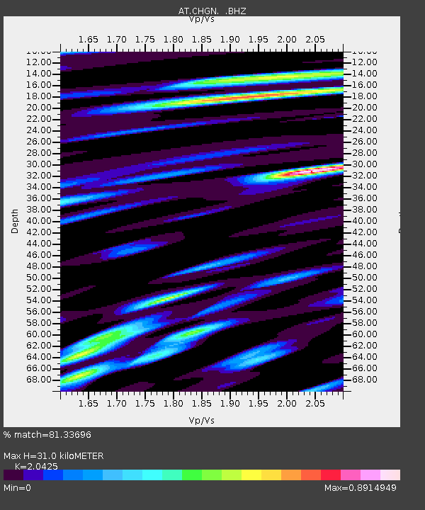
| Estimated Moho Depth: |
31.0 km |
| Estimated Crust Vp/Vs: |
2.04 |
| Assumed Crust Vp: |
6.134 km/s |
| Estimated Crust Vs: |
3.003 km/s |
| Estimated Crust Poisson's Ratio: |
0.34 |
|
| Radial Match: |
81.33696 % |
| Radial Bump: |
400 |
| Transverse Match: |
72.20824 % |
| Transverse Bump: |
400 |
| SOD ConfigId: |
626651 |
| Insert Time: |
2014-05-27 06:50:55.275 +0000 |
| GWidth: |
2.5 |
| Max Bumps: |
400 |
| Tol: |
0.001 |
|

Signal To Noise
| Channel | StoN | STA | LTA |
| AT:CHGN: :BHZ:20140513T06:46:42.03999Z | 7.443847 | 1.2589335E-6 | 1.6912404E-7 |
| AT:CHGN: :BHN:20140513T06:46:42.03999Z | 1.2758026 | 2.8662868E-7 | 2.2466538E-7 |
| AT:CHGN: :BHE:20140513T06:46:42.03999Z | 3.9191308 | 4.8427097E-7 | 1.2356591E-7 |
| Arrivals |
| Ps | 5.4 SECOND |
| PpPs | 15 SECOND |
| PsPs/PpSs | 20 SECOND |


