You are here: Home > Network List > UW - Pacific Northwest Regional Seismic Network Stations List
> Station LTY Liberty (broad-band) > Earthquake Result Viewer
LTY Liberty (broad-band) - Earthquake Result Viewer
| Earthquake location: |
Off Coast Of Jalisco, Mexico |
| Earthquake latitude/longitude: |
18.7/-106.8 |
| Earthquake time(UTC): |
2015/02/22 (053) 14:23:14 GMT |
| Earthquake Depth: |
10 km |
| Earthquake Magnitude: |
6.2 MO |
| Earthquake Catalog/Contributor: |
NEIC PDE/NEIC ALERT |
|
| Network: |
UW Pacific Northwest Regional Seismic Network |
| Station: |
LTY Liberty (broad-band) |
| Lat/Lon: |
47.26 N/120.66 W |
| Elevation: |
970 m |
|
| Distance: |
30.6 deg |
| Az: |
341.332 deg |
| Baz: |
153.554 deg |
| Ray Param: |
0.07927719 |
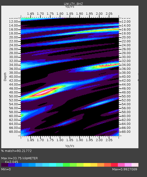
| Estimated Moho Depth: |
33.75 km |
| Estimated Crust Vp/Vs: |
2.05 |
| Assumed Crust Vp: |
6.597 km/s |
| Estimated Crust Vs: |
3.226 km/s |
| Estimated Crust Poisson's Ratio: |
0.34 |
|
| Radial Match: |
90.21772 % |
| Radial Bump: |
352 |
| Transverse Match: |
83.90271 % |
| Transverse Bump: |
400 |
| SOD ConfigId: |
7019011 |
| Insert Time: |
2019-04-17 00:55:06.742 +0000 |
| GWidth: |
2.5 |
| Max Bumps: |
400 |
| Tol: |
0.001 |
|

Signal To Noise
| Channel | StoN | STA | LTA |
| UW:LTY: :BHZ:20150222T14:28:58.355005Z | 6.2101045 | 9.256022E-7 | 1.4904776E-7 |
| UW:LTY: :BHN:20150222T14:28:58.355005Z | 4.9010425 | 5.913732E-7 | 1.2066273E-7 |
| UW:LTY: :BHE:20150222T14:28:58.355005Z | 1.0924349 | 1.4292776E-7 | 1.3083412E-7 |
| Arrivals |
| Ps | 5.8 SECOND |
| PpPs | 14 SECOND |
| PsPs/PpSs | 20 SECOND |


