You are here: Home > Network List > X812 - Deep Structure of Three Continental Sutures in Eastern North America Stations List
> Station QM28 6 mile checkpoint, Maine, USA > Earthquake Result Viewer
QM28 6 mile checkpoint, Maine, USA - Earthquake Result Viewer
| Earthquake location: |
Off Coast Of Jalisco, Mexico |
| Earthquake latitude/longitude: |
18.7/-106.8 |
| Earthquake time(UTC): |
2015/02/22 (053) 14:23:14 GMT |
| Earthquake Depth: |
10 km |
| Earthquake Magnitude: |
6.2 MO |
| Earthquake Catalog/Contributor: |
NEIC PDE/NEIC ALERT |
|
| Network: |
X8 Deep Structure of Three Continental Sutures in Eastern North America |
| Station: |
QM28 6 mile checkpoint, Maine, USA |
| Lat/Lon: |
46.64 N/68.53 W |
| Elevation: |
212 m |
|
| Distance: |
41.9 deg |
| Az: |
39.693 deg |
| Baz: |
241.455 deg |
| Ray Param: |
0.07347185 |
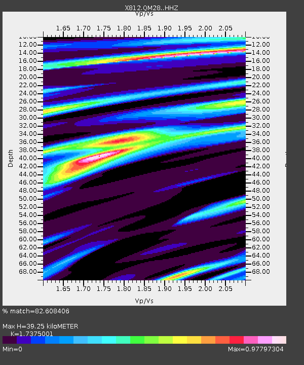
| Estimated Moho Depth: |
39.25 km |
| Estimated Crust Vp/Vs: |
1.74 |
| Assumed Crust Vp: |
6.419 km/s |
| Estimated Crust Vs: |
3.695 km/s |
| Estimated Crust Poisson's Ratio: |
0.25 |
|
| Radial Match: |
82.608406 % |
| Radial Bump: |
400 |
| Transverse Match: |
53.36301 % |
| Transverse Bump: |
400 |
| SOD ConfigId: |
7019011 |
| Insert Time: |
2019-04-17 00:55:39.847 +0000 |
| GWidth: |
2.5 |
| Max Bumps: |
400 |
| Tol: |
0.001 |
|

Signal To Noise
| Channel | StoN | STA | LTA |
| X8:QM28: :HHZ:20150222T14:30:35.244989Z | 3.1372237 | 9.921765E-7 | 3.1625942E-7 |
| X8:QM28: :HHN:20150222T14:30:35.244989Z | 1.3986386 | 4.4754483E-7 | 3.1998604E-7 |
| X8:QM28: :HHE:20150222T14:30:35.244989Z | 1.2547016 | 6.7355654E-7 | 5.3682606E-7 |
| Arrivals |
| Ps | 4.8 SECOND |
| PpPs | 16 SECOND |
| PsPs/PpSs | 20 SECOND |


