You are here: Home > Network List > XD14 - Illuminating the architecture of the greater Mount St. Helens magmatic systems f Stations List
> Station MF09 "Mount St Helens, WA" > Earthquake Result Viewer
MF09 "Mount St Helens, WA" - Earthquake Result Viewer
| Earthquake location: |
Off Coast Of Jalisco, Mexico |
| Earthquake latitude/longitude: |
18.7/-106.8 |
| Earthquake time(UTC): |
2015/02/22 (053) 14:23:14 GMT |
| Earthquake Depth: |
10 km |
| Earthquake Magnitude: |
6.2 MO |
| Earthquake Catalog/Contributor: |
NEIC PDE/NEIC ALERT |
|
| Network: |
XD Illuminating the architecture of the greater Mount St. Helens magmatic systems f |
| Station: |
MF09 "Mount St Helens, WA" |
| Lat/Lon: |
46.39 N/121.86 W |
| Elevation: |
1216 m |
|
| Distance: |
30.3 deg |
| Az: |
339.101 deg |
| Baz: |
150.761 deg |
| Ray Param: |
0.07937765 |
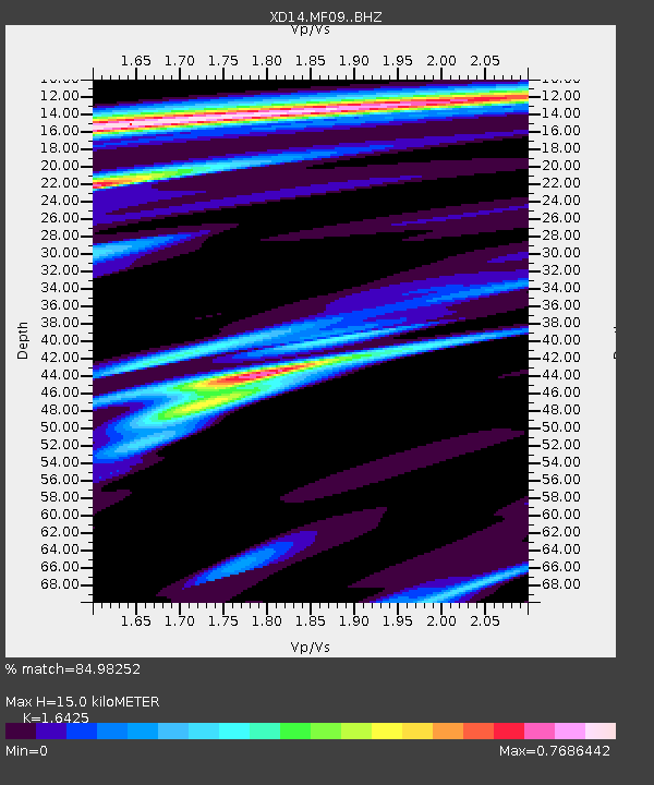
| Estimated Moho Depth: |
15.0 km |
| Estimated Crust Vp/Vs: |
1.64 |
| Assumed Crust Vp: |
6.597 km/s |
| Estimated Crust Vs: |
4.017 km/s |
| Estimated Crust Poisson's Ratio: |
0.21 |
|
| Radial Match: |
84.98252 % |
| Radial Bump: |
400 |
| Transverse Match: |
59.867023 % |
| Transverse Bump: |
400 |
| SOD ConfigId: |
7019011 |
| Insert Time: |
2019-04-17 00:56:00.528 +0000 |
| GWidth: |
2.5 |
| Max Bumps: |
400 |
| Tol: |
0.001 |
|

Signal To Noise
| Channel | StoN | STA | LTA |
| XD:MF09: :BHZ:20150222T14:28:54.925012Z | 6.5251474 | 9.3310064E-7 | 1.4300069E-7 |
| XD:MF09: :BHN:20150222T14:28:54.925012Z | 0.51494145 | 2.6281262E-7 | 5.103738E-7 |
| XD:MF09: :BHE:20150222T14:28:54.925012Z | 0.3666869 | 3.4492766E-7 | 9.406599E-7 |
| Arrivals |
| Ps | 1.6 SECOND |
| PpPs | 5.5 SECOND |
| PsPs/PpSs | 7.1 SECOND |


