You are here: Home > Network List > GS - US Geological Survey Networks Stations List
> Station OK028 N Oak Rd and Britton Rd, Lincoln County > Earthquake Result Viewer
OK028 N Oak Rd and Britton Rd, Lincoln County - Earthquake Result Viewer
| Earthquake location: |
South Of Panama |
| Earthquake latitude/longitude: |
7.2/-82.3 |
| Earthquake time(UTC): |
2014/05/13 (133) 06:35:24 GMT |
| Earthquake Depth: |
10 km |
| Earthquake Magnitude: |
6.8 MWP, 6.8 MI |
| Earthquake Catalog/Contributor: |
NEIC PDE/NEIC COMCAT |
|
| Network: |
GS US Geological Survey Networks |
| Station: |
OK028 N Oak Rd and Britton Rd, Lincoln County |
| Lat/Lon: |
35.56 N/97.06 W |
| Elevation: |
330 m |
|
| Distance: |
31.3 deg |
| Az: |
336.444 deg |
| Baz: |
150.903 deg |
| Ray Param: |
0.07911826 |
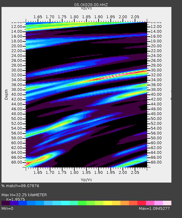
| Estimated Moho Depth: |
32.25 km |
| Estimated Crust Vp/Vs: |
1.96 |
| Assumed Crust Vp: |
6.426 km/s |
| Estimated Crust Vs: |
3.283 km/s |
| Estimated Crust Poisson's Ratio: |
0.32 |
|
| Radial Match: |
89.07976 % |
| Radial Bump: |
291 |
| Transverse Match: |
59.645824 % |
| Transverse Bump: |
400 |
| SOD ConfigId: |
626651 |
| Insert Time: |
2014-05-27 07:02:16.764 +0000 |
| GWidth: |
2.5 |
| Max Bumps: |
400 |
| Tol: |
0.001 |
|

Signal To Noise
| Channel | StoN | STA | LTA |
| GS:OK028:00:HHZ:20140513T06:41:13.619Z | 9.115497 | 1.3500571E-6 | 1.4810571E-7 |
| GS:OK028:00:HH1:20140513T06:41:13.619Z | 1.7069696 | 5.218117E-7 | 3.0569478E-7 |
| GS:OK028:00:HH2:20140513T06:41:13.619Z | 1.2126848 | 4.4035394E-7 | 3.6312315E-7 |
| Arrivals |
| Ps | 5.2 SECOND |
| PpPs | 14 SECOND |
| PsPs/PpSs | 19 SECOND |


