You are here: Home > Network List > II - Global Seismograph Network (GSN - IRIS/IDA) Stations List
> Station PFO Pinon Flat, California, USA > Earthquake Result Viewer
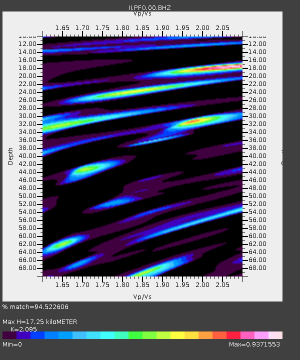
PFO Pinon Flat, California, USA - Earthquake Result Viewer
| Earthquake location: |
South Of Panama |
| Earthquake latitude/longitude: |
7.2/-82.3 |
| Earthquake time(UTC): |
2014/05/13 (133) 06:35:24 GMT |
| Earthquake Depth: |
10 km |
| Earthquake Magnitude: |
6.8 MWP, 6.8 MI |
| Earthquake Catalog/Contributor: |
NEIC PDE/NEIC COMCAT |
|
| Network: |
II Global Seismograph Network (GSN - IRIS/IDA) |
| Station: |
PFO Pinon Flat, California, USA |
| Lat/Lon: |
33.61 N/116.46 W |
| Elevation: |
1280 m |
|
| Distance: |
41.0 deg |
| Az: |
314.497 deg |
| Baz: |
122.007 deg |
| Ray Param: |
0.07405103 |
| Estimated Moho Depth: |
17.25 km |
| Estimated Crust Vp/Vs: |
2.10 |
| Assumed Crust Vp: |
6.264 km/s |
| Estimated Crust Vs: |
2.99 km/s |
| Estimated Crust Poisson's Ratio: |
0.35 |
|
| Radial Match: |
94.522606 % |
| Radial Bump: |
400 |
| Transverse Match: |
92.5368 % |
| Transverse Bump: |
400 |
| SOD ConfigId: |
626651 |
| Insert Time: |
2014-05-27 07:03:58.793 +0000 |
| GWidth: |
2.5 |
| Max Bumps: |
400 |
| Tol: |
0.001 |
|

Signal To Noise
| Channel | StoN | STA | LTA |
| II:PFO:00:BHZ:20140513T06:42:36.969006Z | 18.294796 | 1.9983518E-6 | 1.09230605E-7 |
| II:PFO:00:BH1:20140513T06:42:36.969006Z | 6.1914186 | 5.322508E-7 | 8.596588E-8 |
| II:PFO:00:BH2:20140513T06:42:36.969006Z | 14.216015 | 1.0432858E-6 | 7.338806E-8 |
| Arrivals |
| Ps | 3.2 SECOND |
| PpPs | 8.1 SECOND |
| PsPs/PpSs | 11 SECOND |


