You are here: Home > Network List > XD14 - Illuminating the architecture of the greater Mount St. Helens magmatic systems f Stations List
> Station ML10 "Mount St Helens, WA" > Earthquake Result Viewer
ML10 "Mount St Helens, WA" - Earthquake Result Viewer
| Earthquake location: |
Off Coast Of Jalisco, Mexico |
| Earthquake latitude/longitude: |
18.7/-106.8 |
| Earthquake time(UTC): |
2015/02/22 (053) 14:23:14 GMT |
| Earthquake Depth: |
10 km |
| Earthquake Magnitude: |
6.2 MO |
| Earthquake Catalog/Contributor: |
NEIC PDE/NEIC ALERT |
|
| Network: |
XD Illuminating the architecture of the greater Mount St. Helens magmatic systems f |
| Station: |
ML10 "Mount St Helens, WA" |
| Lat/Lon: |
46.05 N/121.75 W |
| Elevation: |
1238 m |
|
| Distance: |
29.9 deg |
| Az: |
338.905 deg |
| Baz: |
150.671 deg |
| Ray Param: |
0.079464756 |
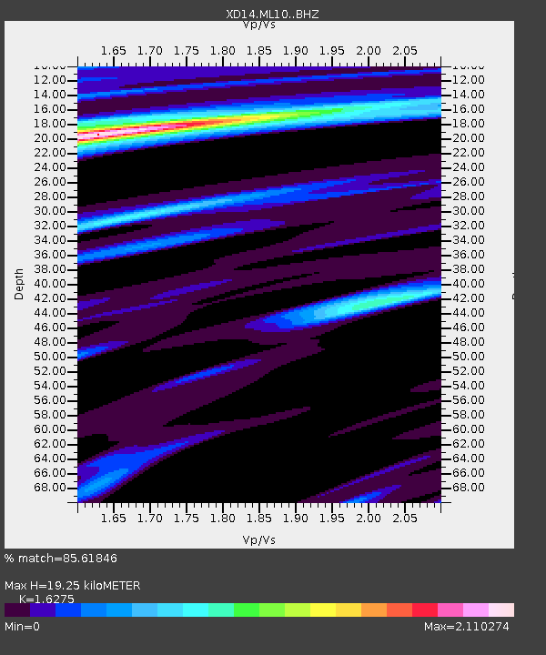
| Estimated Moho Depth: |
19.25 km |
| Estimated Crust Vp/Vs: |
1.63 |
| Assumed Crust Vp: |
6.597 km/s |
| Estimated Crust Vs: |
4.054 km/s |
| Estimated Crust Poisson's Ratio: |
0.20 |
|
| Radial Match: |
85.61846 % |
| Radial Bump: |
400 |
| Transverse Match: |
72.37266 % |
| Transverse Bump: |
400 |
| SOD ConfigId: |
7019011 |
| Insert Time: |
2019-04-17 00:56:27.317 +0000 |
| GWidth: |
2.5 |
| Max Bumps: |
400 |
| Tol: |
0.001 |
|

Signal To Noise
| Channel | StoN | STA | LTA |
| XD:ML10: :BHZ:20150222T14:28:52.010004Z | 8.090164 | 1.1624992E-6 | 1.436929E-7 |
| XD:ML10: :BHN:20150222T14:28:52.010004Z | 0.71431583 | 5.125531E-7 | 7.175441E-7 |
| XD:ML10: :BHE:20150222T14:28:52.010004Z | 0.34942183 | 1.7131634E-7 | 4.9028523E-7 |
| Arrivals |
| Ps | 2.0 SECOND |
| PpPs | 7.0 SECOND |
| PsPs/PpSs | 9.0 SECOND |


