You are here: Home > Network List > XD14 - Illuminating the architecture of the greater Mount St. Helens magmatic systems f Stations List
> Station MN10 "Mount St Helens, WA" > Earthquake Result Viewer
MN10 "Mount St Helens, WA" - Earthquake Result Viewer
| Earthquake location: |
Off Coast Of Jalisco, Mexico |
| Earthquake latitude/longitude: |
18.7/-106.8 |
| Earthquake time(UTC): |
2015/02/22 (053) 14:23:14 GMT |
| Earthquake Depth: |
10 km |
| Earthquake Magnitude: |
6.2 MO |
| Earthquake Catalog/Contributor: |
NEIC PDE/NEIC ALERT |
|
| Network: |
XD Illuminating the architecture of the greater Mount St. Helens magmatic systems f |
| Station: |
MN10 "Mount St Helens, WA" |
| Lat/Lon: |
45.98 N/121.68 W |
| Elevation: |
1091 m |
|
| Distance: |
29.8 deg |
| Az: |
338.921 deg |
| Baz: |
150.735 deg |
| Ray Param: |
0.079487376 |
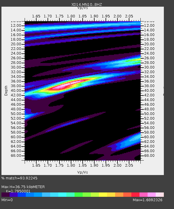
| Estimated Moho Depth: |
36.75 km |
| Estimated Crust Vp/Vs: |
1.80 |
| Assumed Crust Vp: |
6.597 km/s |
| Estimated Crust Vs: |
3.675 km/s |
| Estimated Crust Poisson's Ratio: |
0.27 |
|
| Radial Match: |
93.92245 % |
| Radial Bump: |
357 |
| Transverse Match: |
67.3081 % |
| Transverse Bump: |
400 |
| SOD ConfigId: |
7019011 |
| Insert Time: |
2019-04-17 00:56:32.241 +0000 |
| GWidth: |
2.5 |
| Max Bumps: |
400 |
| Tol: |
0.001 |
|

Signal To Noise
| Channel | StoN | STA | LTA |
| XD:MN10: :BHZ:20150222T14:28:51.240015Z | 6.6519394 | 9.825886E-7 | 1.477146E-7 |
| XD:MN10: :BHN:20150222T14:28:51.240015Z | 1.856832 | 6.0779405E-7 | 3.273285E-7 |
| XD:MN10: :BHE:20150222T14:28:51.240015Z | 1.0212693 | 3.7398547E-7 | 3.6619673E-7 |
| Arrivals |
| Ps | 4.8 SECOND |
| PpPs | 14 SECOND |
| PsPs/PpSs | 19 SECOND |


