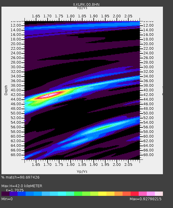
KURK Kurchatov, Kazakhstan - Earthquake Result Viewer
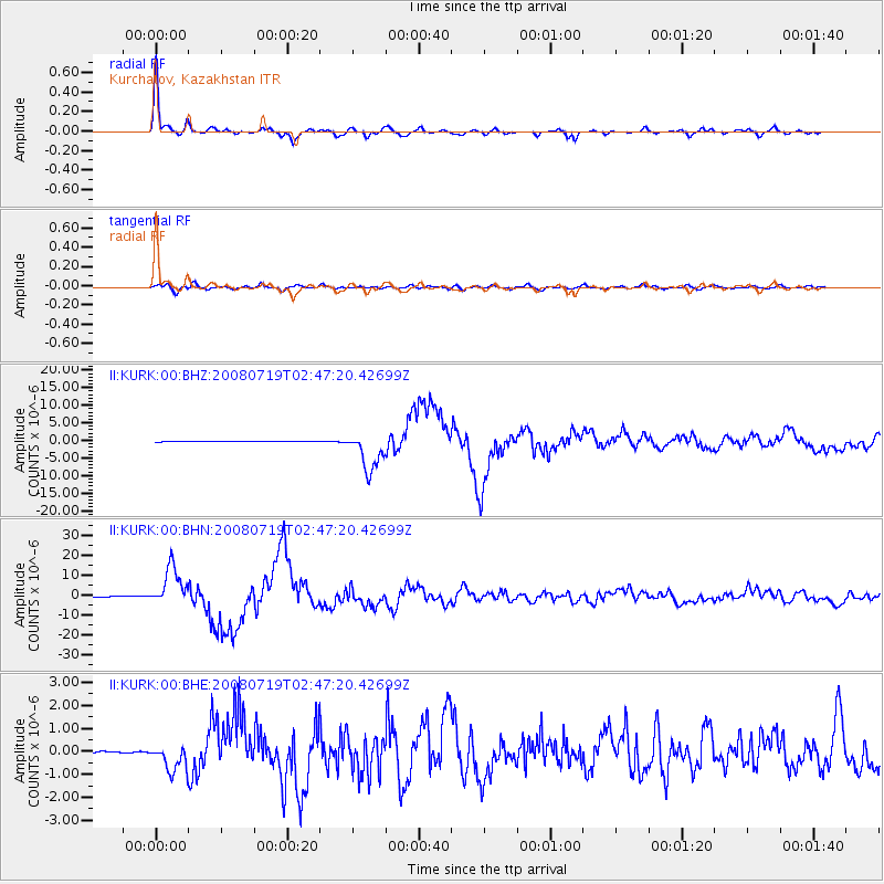
Earthquake location: Off East Coast Of Honshu, Japan
Earthquake latitude/longitude: 37.6/142.2
Earthquake time(UTC): 2008/07/19 (201) 02:39:28 GMT
Earthquake Depth: 22 km
Earthquake Magnitude: 6.2 MB, 7.0 MS, 7.0 MW, 6.9 MW
Earthquake Catalog/Contributor: WHDF/NEIC
Network: II Global Seismograph Network (GSN - IRIS/IDA)
Station: KURK Kurchatov, Kazakhstan
Lat/Lon: 50.72 N/78.62 E
Elevation: 184 m
Distance: 46.1 deg
Az: 307.816 deg
Baz: 80.982 deg
Ray Param: 0.070811994
Estimated Moho Depth: 42.0 km
Estimated Crust Vp/Vs: 1.70
Assumed Crust Vp: 6.552 km/s
Estimated Crust Vs: 3.849 km/s
Estimated Crust Poisson's Ratio: 0.24
Radial Match: 98.697426 %
Radial Bump: 275
Transverse Match: 91.15118 %
Transverse Bump: 400
SOD ConfigId: 2504
Insert Time: 2010-03-01 22:08:37.728 +0000
GWidth: 2.5
Max Bumps: 400
Tol: 0.001

Signal To Noise

ChannelStoNSTALTA
II:KURK:00:BHN:20080719T02:47:20.42699Z110.153569.679679E-68.787441E-8
II:KURK:00:BHE:20080719T02:47:20.42699Z14.1271446.0390124E-74.2747583E-8
II:KURK:00:BHZ:20080719T02:47:20.42699Z91.62025.661334E-66.1791326E-8
Arrivals
Ps4.8 SECOND
PpPs16 SECOND
PsPs/PpSs21 SECOND