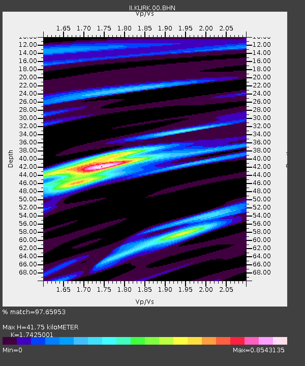
KURK Kurchatov, Kazakhstan - Earthquake Result Viewer
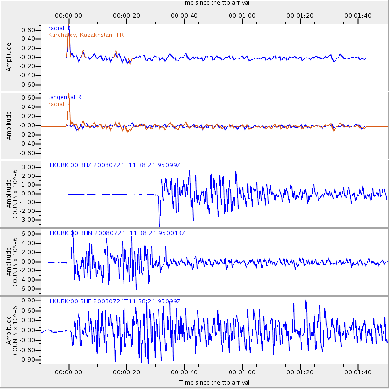
Earthquake location: Off East Coast Of Honshu, Japan
Earthquake latitude/longitude: 37.2/142.1
Earthquake time(UTC): 2008/07/21 (203) 11:30:29 GMT
Earthquake Depth: 22 km
Earthquake Magnitude: 5.7 MB, 5.6 MS, 6.0 MW, 5.9 MW
Earthquake Catalog/Contributor: WHDF/NEIC
Network: II Global Seismograph Network (GSN - IRIS/IDA)
Station: KURK Kurchatov, Kazakhstan
Lat/Lon: 50.72 N/78.62 E
Elevation: 184 m
Distance: 46.2 deg
Az: 308.07 deg
Baz: 81.492 deg
Ray Param: 0.07073629
Estimated Moho Depth: 41.75 km
Estimated Crust Vp/Vs: 1.74
Assumed Crust Vp: 6.552 km/s
Estimated Crust Vs: 3.76 km/s
Estimated Crust Poisson's Ratio: 0.25
Radial Match: 97.65953 %
Radial Bump: 363
Transverse Match: 90.82737 %
Transverse Bump: 400
SOD ConfigId: 2504
Insert Time: 2010-03-01 22:08:38.997 +0000
GWidth: 2.5
Max Bumps: 400
Tol: 0.001

Signal To Noise

ChannelStoNSTALTA
II:KURK:00:BHN:20080721T11:38:21.950013Z70.152932.37646E-63.387542E-8
II:KURK:00:BHE:20080721T11:38:21.95099Z7.47359282.468805E-73.303371E-8
II:KURK:00:BHZ:20080721T11:38:21.95099Z72.272021.2334657E-61.7066988E-8
Arrivals
Ps5.1 SECOND
PpPs16 SECOND
PsPs/PpSs21 SECOND