You are here: Home > Network List > NE - New England Seismic Network Stations List
> Station VT1 Waterbury, VT, USA > Earthquake Result Viewer
VT1 Waterbury, VT, USA - Earthquake Result Viewer
| Earthquake location: |
South Of Panama |
| Earthquake latitude/longitude: |
7.2/-82.3 |
| Earthquake time(UTC): |
2014/05/13 (133) 06:35:24 GMT |
| Earthquake Depth: |
10 km |
| Earthquake Magnitude: |
6.8 MWP, 6.8 MI |
| Earthquake Catalog/Contributor: |
NEIC PDE/NEIC COMCAT |
|
| Network: |
NE New England Seismic Network |
| Station: |
VT1 Waterbury, VT, USA |
| Lat/Lon: |
44.32 N/72.75 W |
| Elevation: |
149 m |
|
| Distance: |
37.9 deg |
| Az: |
11.221 deg |
| Baz: |
195.603 deg |
| Ray Param: |
0.0758944 |
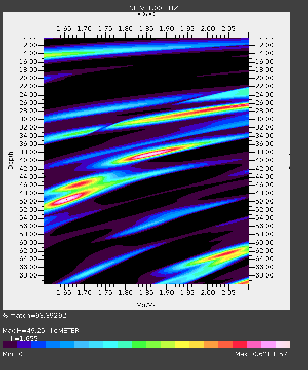
| Estimated Moho Depth: |
49.25 km |
| Estimated Crust Vp/Vs: |
1.65 |
| Assumed Crust Vp: |
6.419 km/s |
| Estimated Crust Vs: |
3.879 km/s |
| Estimated Crust Poisson's Ratio: |
0.21 |
|
| Radial Match: |
93.39292 % |
| Radial Bump: |
217 |
| Transverse Match: |
66.24482 % |
| Transverse Bump: |
400 |
| SOD ConfigId: |
626651 |
| Insert Time: |
2014-05-27 07:12:53.135 +0000 |
| GWidth: |
2.5 |
| Max Bumps: |
400 |
| Tol: |
0.001 |
|

Signal To Noise
| Channel | StoN | STA | LTA |
| NE:VT1:00:HHZ:20140513T06:42:10.629987Z | 6.7807403 | 1.7030424E-6 | 2.5115875E-7 |
| NE:VT1:00:HH1:20140513T06:42:10.629987Z | 2.6084857 | 8.467114E-7 | 3.2459883E-7 |
| NE:VT1:00:HH2:20140513T06:42:10.629987Z | 4.3122287 | 1.0313174E-6 | 2.3916112E-7 |
| Arrivals |
| Ps | 5.4 SECOND |
| PpPs | 19 SECOND |
| PsPs/PpSs | 24 SECOND |


