You are here: Home > Network List > NE - New England Seismic Network Stations List
> Station WVL Waterville, ME, USA > Earthquake Result Viewer
WVL Waterville, ME, USA - Earthquake Result Viewer
| Earthquake location: |
South Of Panama |
| Earthquake latitude/longitude: |
7.2/-82.3 |
| Earthquake time(UTC): |
2014/05/13 (133) 06:35:24 GMT |
| Earthquake Depth: |
10 km |
| Earthquake Magnitude: |
6.8 MWP, 6.8 MI |
| Earthquake Catalog/Contributor: |
NEIC PDE/NEIC COMCAT |
|
| Network: |
NE New England Seismic Network |
| Station: |
WVL Waterville, ME, USA |
| Lat/Lon: |
44.56 N/69.66 W |
| Elevation: |
50 m |
|
| Distance: |
38.8 deg |
| Az: |
14.495 deg |
| Baz: |
200.328 deg |
| Ray Param: |
0.07536526 |
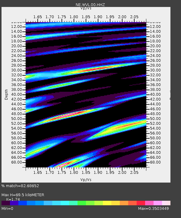
| Estimated Moho Depth: |
69.5 km |
| Estimated Crust Vp/Vs: |
1.74 |
| Assumed Crust Vp: |
6.419 km/s |
| Estimated Crust Vs: |
3.689 km/s |
| Estimated Crust Poisson's Ratio: |
0.25 |
|
| Radial Match: |
82.68652 % |
| Radial Bump: |
245 |
| Transverse Match: |
59.398605 % |
| Transverse Bump: |
351 |
| SOD ConfigId: |
626651 |
| Insert Time: |
2014-05-27 07:13:39.592 +0000 |
| GWidth: |
2.5 |
| Max Bumps: |
400 |
| Tol: |
0.001 |
|

Signal To Noise
| Channel | StoN | STA | LTA |
| NE:WVL:00:HHZ:20140513T06:42:18.323987Z | 4.1980104 | 1.572429E-6 | 3.745653E-7 |
| NE:WVL:00:HH1:20140513T06:42:18.323987Z | 2.6610672 | 9.415553E-7 | 3.5382618E-7 |
| NE:WVL:00:HH2:20140513T06:42:18.323987Z | 2.1205873 | 4.6781776E-7 | 2.2060763E-7 |
| Arrivals |
| Ps | 8.6 SECOND |
| PpPs | 28 SECOND |
| PsPs/PpSs | 36 SECOND |


