You are here: Home > Network List > TA - USArray Transportable Network (new EarthScope stations) Stations List
> Station U57A Blanch, NC, USA > Earthquake Result Viewer
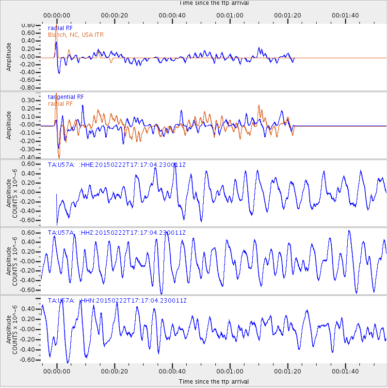
U57A Blanch, NC, USA - Earthquake Result Viewer
*The percent match for this event was below the threshold and hence no stack was calculated.
| Earthquake location: |
Northern Mid-Atlantic Ridge |
| Earthquake latitude/longitude: |
20.0/-45.8 |
| Earthquake time(UTC): |
2015/02/22 (053) 17:10:54 GMT |
| Earthquake Depth: |
10 km |
| Earthquake Magnitude: |
5.0 MW |
| Earthquake Catalog/Contributor: |
ISC/ISC |
|
| Network: |
TA USArray Transportable Network (new EarthScope stations) |
| Station: |
U57A Blanch, NC, USA |
| Lat/Lon: |
36.43 N/79.34 W |
| Elevation: |
178 m |
|
| Distance: |
33.6 deg |
| Az: |
306.293 deg |
| Baz: |
109.976 deg |
| Ray Param: |
$rayparam |
*The percent match for this event was below the threshold and hence was not used in the summary stack. |
|
| Radial Match: |
36.383854 % |
| Radial Bump: |
400 |
| Transverse Match: |
51.206623 % |
| Transverse Bump: |
400 |
| SOD ConfigId: |
7019011 |
| Insert Time: |
2019-04-17 01:03:54.603 +0000 |
| GWidth: |
2.5 |
| Max Bumps: |
400 |
| Tol: |
0.001 |
|
Signal To Noise
| Channel | StoN | STA | LTA |
| TA:U57A: :HHZ:20150222T17:17:04.230011Z | 0.8678962 | 2.7371357E-7 | 3.1537593E-7 |
| TA:U57A: :HHN:20150222T17:17:04.230011Z | 2.2564132 | 4.0861832E-7 | 1.8109196E-7 |
| TA:U57A: :HHE:20150222T17:17:04.230011Z | 1.805464 | 3.07784E-7 | 1.7047363E-7 |
| Arrivals |
| Ps | |
| PpPs | |
| PsPs/PpSs | |


