You are here: Home > Network List > NM - Cooperative New Madrid Seismic Network Stations List
> Station MGMO Mountain Grove, MO > Earthquake Result Viewer
MGMO Mountain Grove, MO - Earthquake Result Viewer
| Earthquake location: |
South Of Panama |
| Earthquake latitude/longitude: |
7.2/-82.3 |
| Earthquake time(UTC): |
2014/05/13 (133) 06:35:24 GMT |
| Earthquake Depth: |
10 km |
| Earthquake Magnitude: |
6.8 MWP, 6.8 MI |
| Earthquake Catalog/Contributor: |
NEIC PDE/NEIC COMCAT |
|
| Network: |
NM Cooperative New Madrid Seismic Network |
| Station: |
MGMO Mountain Grove, MO |
| Lat/Lon: |
37.15 N/92.27 W |
| Elevation: |
453 m |
|
| Distance: |
31.1 deg |
| Az: |
344.522 deg |
| Baz: |
160.647 deg |
| Ray Param: |
0.07915476 |
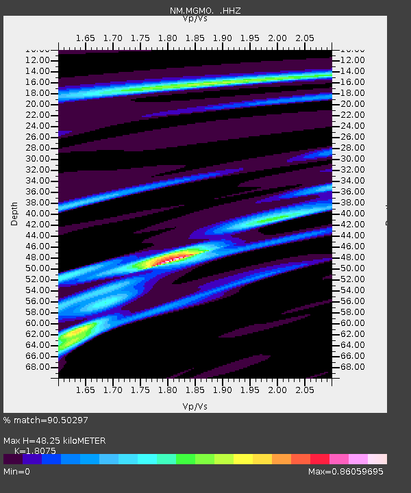
| Estimated Moho Depth: |
48.25 km |
| Estimated Crust Vp/Vs: |
1.81 |
| Assumed Crust Vp: |
6.53 km/s |
| Estimated Crust Vs: |
3.613 km/s |
| Estimated Crust Poisson's Ratio: |
0.28 |
|
| Radial Match: |
90.50297 % |
| Radial Bump: |
174 |
| Transverse Match: |
82.68891 % |
| Transverse Bump: |
344 |
| SOD ConfigId: |
626651 |
| Insert Time: |
2014-05-27 07:14:55.248 +0000 |
| GWidth: |
2.5 |
| Max Bumps: |
400 |
| Tol: |
0.001 |
|

Signal To Noise
| Channel | StoN | STA | LTA |
| NM:MGMO: :HHZ:20140513T06:41:12.388013Z | 30.658957 | 2.7601575E-6 | 9.002777E-8 |
| NM:MGMO: :HHN:20140513T06:41:12.388013Z | 9.341501 | 1.6377352E-6 | 1.7531819E-7 |
| NM:MGMO: :HHE:20140513T06:41:12.388013Z | 4.651549 | 3.8594308E-7 | 8.297087E-8 |
| Arrivals |
| Ps | 6.5 SECOND |
| PpPs | 19 SECOND |
| PsPs/PpSs | 26 SECOND |


