You are here: Home > Network List > US - United States National Seismic Network Stations List
> Station AMTX Amarillo, Texas, USA > Earthquake Result Viewer
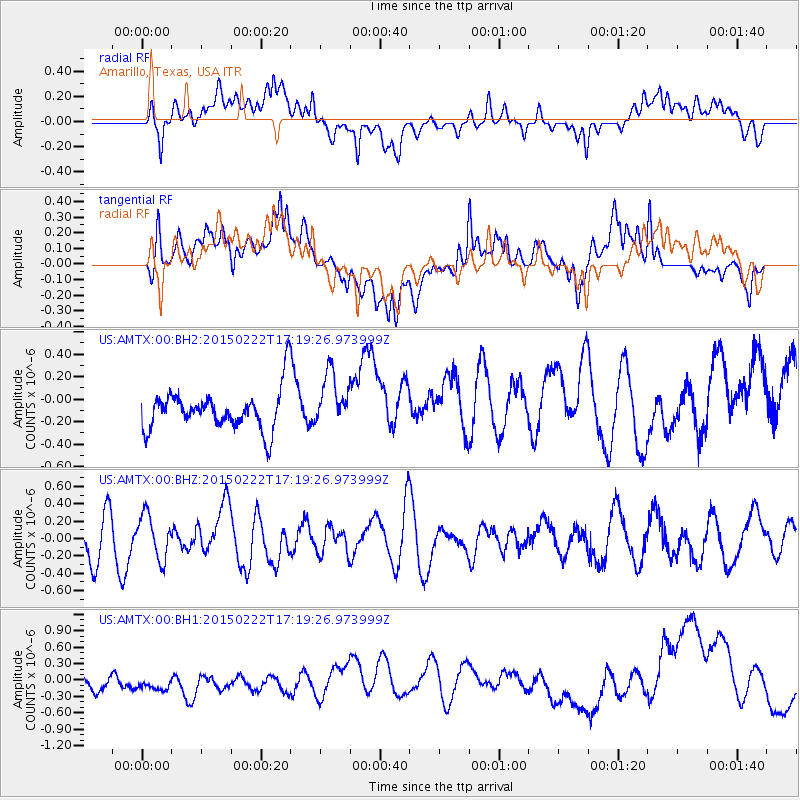
AMTX Amarillo, Texas, USA - Earthquake Result Viewer
*The percent match for this event was below the threshold and hence no stack was calculated.
| Earthquake location: |
Northern Mid-Atlantic Ridge |
| Earthquake latitude/longitude: |
20.0/-45.8 |
| Earthquake time(UTC): |
2015/02/22 (053) 17:10:54 GMT |
| Earthquake Depth: |
10 km |
| Earthquake Magnitude: |
5.0 MW |
| Earthquake Catalog/Contributor: |
ISC/ISC |
|
| Network: |
US United States National Seismic Network |
| Station: |
AMTX Amarillo, Texas, USA |
| Lat/Lon: |
34.53 N/101.41 W |
| Elevation: |
1010 m |
|
| Distance: |
50.9 deg |
| Az: |
298.634 deg |
| Baz: |
91.377 deg |
| Ray Param: |
$rayparam |
*The percent match for this event was below the threshold and hence was not used in the summary stack. |
|
| Radial Match: |
37.18512 % |
| Radial Bump: |
400 |
| Transverse Match: |
34.752064 % |
| Transverse Bump: |
400 |
| SOD ConfigId: |
7019011 |
| Insert Time: |
2019-04-17 01:04:12.224 +0000 |
| GWidth: |
2.5 |
| Max Bumps: |
400 |
| Tol: |
0.001 |
|
Signal To Noise
| Channel | StoN | STA | LTA |
| US:AMTX:00:BHZ:20150222T17:19:26.973999Z | 0.83207315 | 2.5321333E-7 | 3.043162E-7 |
| US:AMTX:00:BH1:20150222T17:19:26.973999Z | 1.1054697 | 3.4510322E-7 | 3.121779E-7 |
| US:AMTX:00:BH2:20150222T17:19:26.973999Z | 1.9184865 | 2.5064918E-7 | 1.3064944E-7 |
| Arrivals |
| Ps | |
| PpPs | |
| PsPs/PpSs | |


