You are here: Home > Network List > TA - USArray Transportable Network (new EarthScope stations) Stations List
> Station BGNE Belgrade, NE, USA > Earthquake Result Viewer
BGNE Belgrade, NE, USA - Earthquake Result Viewer
| Earthquake location: |
South Of Panama |
| Earthquake latitude/longitude: |
7.2/-82.3 |
| Earthquake time(UTC): |
2014/05/13 (133) 06:35:24 GMT |
| Earthquake Depth: |
10 km |
| Earthquake Magnitude: |
6.8 MWP, 6.8 MI |
| Earthquake Catalog/Contributor: |
NEIC PDE/NEIC COMCAT |
|
| Network: |
TA USArray Transportable Network (new EarthScope stations) |
| Station: |
BGNE Belgrade, NE, USA |
| Lat/Lon: |
41.41 N/98.15 W |
| Elevation: |
573 m |
|
| Distance: |
36.8 deg |
| Az: |
339.986 deg |
| Baz: |
153.166 deg |
| Ray Param: |
0.07647721 |
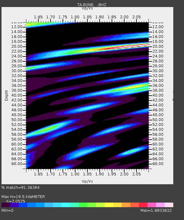
| Estimated Moho Depth: |
19.5 km |
| Estimated Crust Vp/Vs: |
2.05 |
| Assumed Crust Vp: |
6.53 km/s |
| Estimated Crust Vs: |
3.182 km/s |
| Estimated Crust Poisson's Ratio: |
0.34 |
|
| Radial Match: |
91.36394 % |
| Radial Bump: |
368 |
| Transverse Match: |
72.55169 % |
| Transverse Bump: |
400 |
| SOD ConfigId: |
626651 |
| Insert Time: |
2014-05-27 07:19:46.956 +0000 |
| GWidth: |
2.5 |
| Max Bumps: |
400 |
| Tol: |
0.001 |
|

Signal To Noise
| Channel | StoN | STA | LTA |
| TA:BGNE: :BHZ:20140513T06:42:01.724011Z | 10.510218 | 2.4636836E-6 | 2.3440843E-7 |
| TA:BGNE: :BHN:20140513T06:42:01.724011Z | 7.465619 | 1.9296738E-6 | 2.5847473E-7 |
| TA:BGNE: :BHE:20140513T06:42:01.724011Z | 3.7106216 | 1.3306915E-6 | 3.5861686E-7 |
| Arrivals |
| Ps | 3.4 SECOND |
| PpPs | 8.5 SECOND |
| PsPs/PpSs | 12 SECOND |


