You are here: Home > Network List > TA - USArray Transportable Network (new EarthScope stations) Stations List
> Station D46A Sault St. Marie, ON, CAN > Earthquake Result Viewer
D46A Sault St. Marie, ON, CAN - Earthquake Result Viewer
| Earthquake location: |
South Of Panama |
| Earthquake latitude/longitude: |
7.2/-82.3 |
| Earthquake time(UTC): |
2014/05/13 (133) 06:35:24 GMT |
| Earthquake Depth: |
10 km |
| Earthquake Magnitude: |
6.8 MWP, 6.8 MI |
| Earthquake Catalog/Contributor: |
NEIC PDE/NEIC COMCAT |
|
| Network: |
TA USArray Transportable Network (new EarthScope stations) |
| Station: |
D46A Sault St. Marie, ON, CAN |
| Lat/Lon: |
46.89 N/84.04 W |
| Elevation: |
353 m |
|
| Distance: |
39.5 deg |
| Az: |
358.161 deg |
| Baz: |
177.34 deg |
| Ray Param: |
0.07493416 |
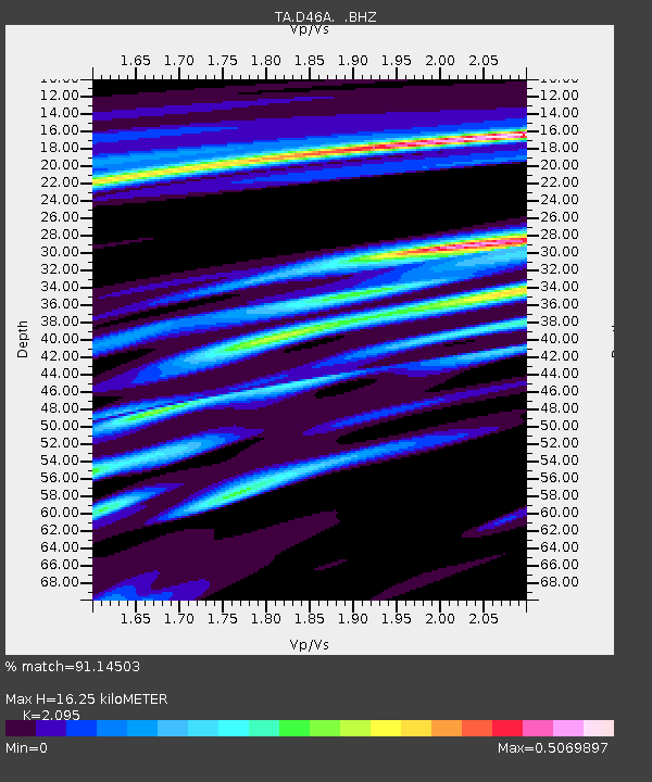
| Estimated Moho Depth: |
16.25 km |
| Estimated Crust Vp/Vs: |
2.10 |
| Assumed Crust Vp: |
6.467 km/s |
| Estimated Crust Vs: |
3.087 km/s |
| Estimated Crust Poisson's Ratio: |
0.35 |
|
| Radial Match: |
91.14503 % |
| Radial Bump: |
204 |
| Transverse Match: |
69.38775 % |
| Transverse Bump: |
391 |
| SOD ConfigId: |
626651 |
| Insert Time: |
2014-05-27 07:20:10.095 +0000 |
| GWidth: |
2.5 |
| Max Bumps: |
400 |
| Tol: |
0.001 |
|

Signal To Noise
| Channel | StoN | STA | LTA |
| TA:D46A: :BHZ:20140513T06:42:24.574994Z | 5.7512274 | 1.3344022E-6 | 2.3202043E-7 |
| TA:D46A: :BHN:20140513T06:42:24.574994Z | 2.532116 | 6.582682E-7 | 2.5996763E-7 |
| TA:D46A: :BHE:20140513T06:42:24.574994Z | 1.6195227 | 2.42124E-7 | 1.495033E-7 |
| Arrivals |
| Ps | 2.9 SECOND |
| PpPs | 7.3 SECOND |
| PsPs/PpSs | 10 SECOND |


