You are here: Home > Network List > TA - USArray Transportable Network (new EarthScope stations) Stations List
> Station D63A Stockholm, ME, USA > Earthquake Result Viewer
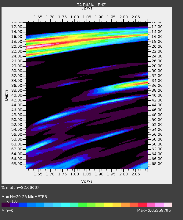
D63A Stockholm, ME, USA - Earthquake Result Viewer
| Earthquake location: |
South Of Panama |
| Earthquake latitude/longitude: |
7.2/-82.3 |
| Earthquake time(UTC): |
2014/05/13 (133) 06:35:24 GMT |
| Earthquake Depth: |
10 km |
| Earthquake Magnitude: |
6.8 MWP, 6.8 MI |
| Earthquake Catalog/Contributor: |
NEIC PDE/NEIC COMCAT |
|
| Network: |
TA USArray Transportable Network (new EarthScope stations) |
| Station: |
D63A Stockholm, ME, USA |
| Lat/Lon: |
47.04 N/68.11 W |
| Elevation: |
256 m |
|
| Distance: |
41.5 deg |
| Az: |
14.699 deg |
| Baz: |
201.595 deg |
| Ray Param: |
0.073767774 |
| Estimated Moho Depth: |
20.25 km |
| Estimated Crust Vp/Vs: |
1.60 |
| Assumed Crust Vp: |
6.419 km/s |
| Estimated Crust Vs: |
4.012 km/s |
| Estimated Crust Poisson's Ratio: |
0.18 |
|
| Radial Match: |
82.06067 % |
| Radial Bump: |
400 |
| Transverse Match: |
76.88906 % |
| Transverse Bump: |
400 |
| SOD ConfigId: |
626651 |
| Insert Time: |
2014-05-27 07:21:14.820 +0000 |
| GWidth: |
2.5 |
| Max Bumps: |
400 |
| Tol: |
0.001 |
|

Signal To Noise
| Channel | StoN | STA | LTA |
| TA:D63A: :BHZ:20140513T06:42:40.675Z | 4.881792 | 2.0280822E-6 | 4.1543802E-7 |
| TA:D63A: :BHN:20140513T06:42:40.675Z | 2.8090088 | 1.2404831E-6 | 4.416088E-7 |
| TA:D63A: :BHE:20140513T06:42:40.675Z | 2.1292546 | 4.901342E-7 | 2.3019051E-7 |
| Arrivals |
| Ps | 2.0 SECOND |
| PpPs | 7.6 SECOND |
| PsPs/PpSs | 9.6 SECOND |


