You are here: Home > Network List > TA - USArray Transportable Network (new EarthScope stations) Stations List
> Station E47A Iron Bridge, ON, CAN > Earthquake Result Viewer
E47A Iron Bridge, ON, CAN - Earthquake Result Viewer

| Earthquake location: |
South Of Panama |
| Earthquake latitude/longitude: |
7.2/-82.3 |
| Earthquake time(UTC): |
2014/05/13 (133) 06:35:24 GMT |
| Earthquake Depth: |
10 km |
| Earthquake Magnitude: |
6.8 MWP, 6.8 MI |
| Earthquake Catalog/Contributor: |
NEIC PDE/NEIC COMCAT |
|
| Network: |
TA USArray Transportable Network (new EarthScope stations) |
| Station: |
E47A Iron Bridge, ON, CAN |
| Lat/Lon: |
46.45 N/83.28 W |
| Elevation: |
246 m |
|
| Distance: |
39.1 deg |
| Az: |
358.96 deg |
| Baz: |
178.508 deg |
| Ray Param: |
0.075197026 |
| Estimated Moho Depth: |
17.0 km |
| Estimated Crust Vp/Vs: |
1.84 |
| Assumed Crust Vp: |
6.467 km/s |
| Estimated Crust Vs: |
3.51 km/s |
| Estimated Crust Poisson's Ratio: |
0.29 |
|
| Radial Match: |
90.74616 % |
| Radial Bump: |
182 |
| Transverse Match: |
57.270866 % |
| Transverse Bump: |
361 |
| SOD ConfigId: |
626651 |
| Insert Time: |
2014-05-27 07:21:25.373 +0000 |
| GWidth: |
2.5 |
| Max Bumps: |
400 |
| Tol: |
0.001 |
|
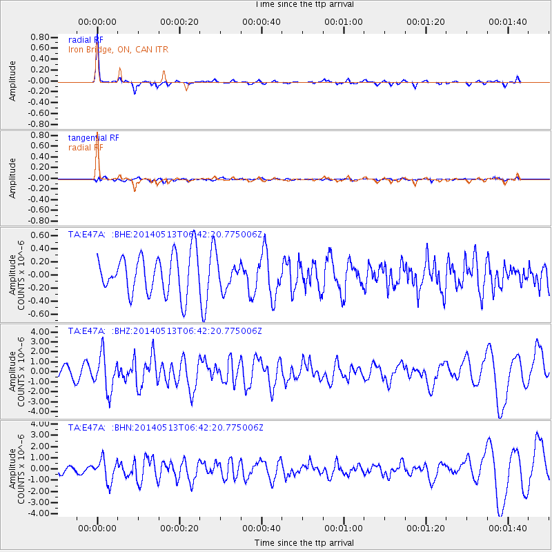
Signal To Noise
| Channel | StoN | STA | LTA |
| TA:E47A: :BHZ:20140513T06:42:20.775006Z | 3.8276968 | 1.8437846E-6 | 4.8169557E-7 |
| TA:E47A: :BHN:20140513T06:42:20.775006Z | 3.7794414 | 1.0173532E-6 | 2.6918082E-7 |
| TA:E47A: :BHE:20140513T06:42:20.775006Z | 0.63901097 | 1.9250564E-7 | 3.0125562E-7 |
| Arrivals |
| Ps | 2.4 SECOND |
| PpPs | 7.0 SECOND |
| PsPs/PpSs | 9.3 SECOND |


