You are here: Home > Network List > TA - USArray Transportable Network (new EarthScope stations) Stations List
> Station E64A Bridgewater, ME, USA > Earthquake Result Viewer
E64A Bridgewater, ME, USA - Earthquake Result Viewer

| Earthquake location: |
South Of Panama |
| Earthquake latitude/longitude: |
7.2/-82.3 |
| Earthquake time(UTC): |
2014/05/13 (133) 06:35:24 GMT |
| Earthquake Depth: |
10 km |
| Earthquake Magnitude: |
6.8 MWP, 6.8 MI |
| Earthquake Catalog/Contributor: |
NEIC PDE/NEIC COMCAT |
|
| Network: |
TA USArray Transportable Network (new EarthScope stations) |
| Station: |
E64A Bridgewater, ME, USA |
| Lat/Lon: |
46.42 N/67.83 W |
| Elevation: |
190 m |
|
| Distance: |
41.0 deg |
| Az: |
15.319 deg |
| Baz: |
202.263 deg |
| Ray Param: |
0.07408129 |
| Estimated Moho Depth: |
10.0 km |
| Estimated Crust Vp/Vs: |
1.78 |
| Assumed Crust Vp: |
6.419 km/s |
| Estimated Crust Vs: |
3.601 km/s |
| Estimated Crust Poisson's Ratio: |
0.27 |
|
| Radial Match: |
83.46997 % |
| Radial Bump: |
400 |
| Transverse Match: |
64.480225 % |
| Transverse Bump: |
400 |
| SOD ConfigId: |
626651 |
| Insert Time: |
2014-05-27 07:22:21.804 +0000 |
| GWidth: |
2.5 |
| Max Bumps: |
400 |
| Tol: |
0.001 |
|
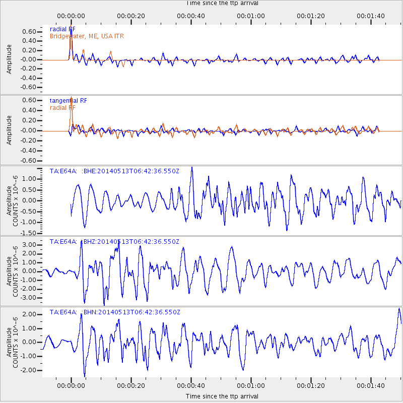
Signal To Noise
| Channel | StoN | STA | LTA |
| TA:E64A: :BHZ:20140513T06:42:36.550Z | 4.9194183 | 1.598182E-6 | 3.2487213E-7 |
| TA:E64A: :BHN:20140513T06:42:36.550Z | 3.8945432 | 1.0750794E-6 | 2.7604761E-7 |
| TA:E64A: :BHE:20140513T06:42:36.550Z | 0.75317425 | 3.1246952E-7 | 4.1487013E-7 |
| Arrivals |
| Ps | 1.3 SECOND |
| PpPs | 4.0 SECOND |
| PsPs/PpSs | 5.4 SECOND |


