You are here: Home > Network List > TA - USArray Transportable Network (new EarthScope stations) Stations List
> Station I45A Fountain, MI, USA > Earthquake Result Viewer
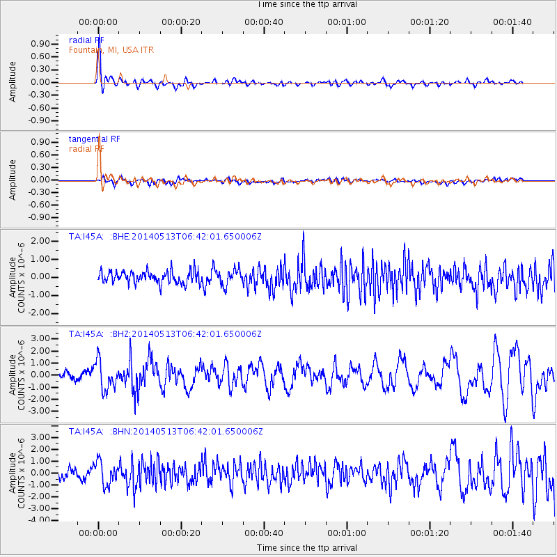
I45A Fountain, MI, USA - Earthquake Result Viewer
*The percent match for this event was below the threshold and hence no stack was calculated.
| Earthquake location: |
South Of Panama |
| Earthquake latitude/longitude: |
7.2/-82.3 |
| Earthquake time(UTC): |
2014/05/13 (133) 06:35:24 GMT |
| Earthquake Depth: |
10 km |
| Earthquake Magnitude: |
6.8 MWP, 6.8 MI |
| Earthquake Catalog/Contributor: |
NEIC PDE/NEIC COMCAT |
|
| Network: |
TA USArray Transportable Network (new EarthScope stations) |
| Station: |
I45A Fountain, MI, USA |
| Lat/Lon: |
44.04 N/86.23 W |
| Elevation: |
215 m |
|
| Distance: |
36.8 deg |
| Az: |
355.297 deg |
| Baz: |
173.524 deg |
| Ray Param: |
$rayparam |
*The percent match for this event was below the threshold and hence was not used in the summary stack. |
|
| Radial Match: |
78.16485 % |
| Radial Bump: |
400 |
| Transverse Match: |
54.85492 % |
| Transverse Bump: |
400 |
| SOD ConfigId: |
626651 |
| Insert Time: |
2014-05-27 07:26:41.850 +0000 |
| GWidth: |
2.5 |
| Max Bumps: |
400 |
| Tol: |
0.001 |
|
Signal To Noise
| Channel | StoN | STA | LTA |
| TA:I45A: :BHZ:20140513T06:42:01.650006Z | 3.8309948 | 1.219074E-6 | 3.182134E-7 |
| TA:I45A: :BHN:20140513T06:42:01.650006Z | 1.8309113 | 9.779274E-7 | 5.341206E-7 |
| TA:I45A: :BHE:20140513T06:42:01.650006Z | 1.3138695 | 4.40108E-7 | 3.3497088E-7 |
| Arrivals |
| Ps | |
| PpPs | |
| PsPs/PpSs | |


