You are here: Home > Network List > TA - USArray Transportable Network (new EarthScope stations) Stations List
> Station I62A Tamworth, NH, USA > Earthquake Result Viewer
I62A Tamworth, NH, USA - Earthquake Result Viewer
| Earthquake location: |
South Of Panama |
| Earthquake latitude/longitude: |
7.2/-82.3 |
| Earthquake time(UTC): |
2014/05/13 (133) 06:35:24 GMT |
| Earthquake Depth: |
10 km |
| Earthquake Magnitude: |
6.8 MWP, 6.8 MI |
| Earthquake Catalog/Contributor: |
NEIC PDE/NEIC COMCAT |
|
| Network: |
TA USArray Transportable Network (new EarthScope stations) |
| Station: |
I62A Tamworth, NH, USA |
| Lat/Lon: |
43.87 N/71.34 W |
| Elevation: |
264 m |
|
| Distance: |
37.7 deg |
| Az: |
13.024 deg |
| Baz: |
198.009 deg |
| Ray Param: |
0.07597128 |
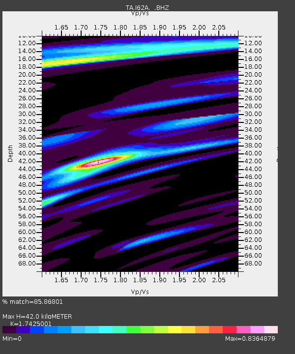
| Estimated Moho Depth: |
42.0 km |
| Estimated Crust Vp/Vs: |
1.74 |
| Assumed Crust Vp: |
6.419 km/s |
| Estimated Crust Vs: |
3.684 km/s |
| Estimated Crust Poisson's Ratio: |
0.25 |
|
| Radial Match: |
85.86801 % |
| Radial Bump: |
310 |
| Transverse Match: |
55.844296 % |
| Transverse Bump: |
400 |
| SOD ConfigId: |
626651 |
| Insert Time: |
2014-05-27 07:27:29.008 +0000 |
| GWidth: |
2.5 |
| Max Bumps: |
400 |
| Tol: |
0.001 |
|

Signal To Noise
| Channel | StoN | STA | LTA |
| TA:I62A: :BHZ:20140513T06:42:09.525006Z | 3.9317331 | 1.4779043E-6 | 3.7589132E-7 |
| TA:I62A: :BHN:20140513T06:42:09.525006Z | 1.6132541 | 6.0644095E-7 | 3.7591164E-7 |
| TA:I62A: :BHE:20140513T06:42:09.525006Z | 1.4310136 | 3.763059E-7 | 2.629646E-7 |
| Arrivals |
| Ps | 5.2 SECOND |
| PpPs | 17 SECOND |
| PsPs/PpSs | 22 SECOND |


