You are here: Home > Network List > TA - USArray Transportable Network (new EarthScope stations) Stations List
> Station J05D Fort Rock, OR, USA > Earthquake Result Viewer
J05D Fort Rock, OR, USA - Earthquake Result Viewer
| Earthquake location: |
South Of Panama |
| Earthquake latitude/longitude: |
7.2/-82.3 |
| Earthquake time(UTC): |
2014/05/13 (133) 06:35:24 GMT |
| Earthquake Depth: |
10 km |
| Earthquake Magnitude: |
6.8 MWP, 6.8 MI |
| Earthquake Catalog/Contributor: |
NEIC PDE/NEIC COMCAT |
|
| Network: |
TA USArray Transportable Network (new EarthScope stations) |
| Station: |
J05D Fort Rock, OR, USA |
| Lat/Lon: |
43.28 N/121.23 W |
| Elevation: |
1541 m |
|
| Distance: |
49.5 deg |
| Az: |
322.907 deg |
| Baz: |
124.977 deg |
| Ray Param: |
0.068660095 |
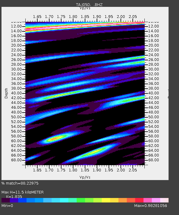
| Estimated Moho Depth: |
11.5 km |
| Estimated Crust Vp/Vs: |
1.84 |
| Assumed Crust Vp: |
6.597 km/s |
| Estimated Crust Vs: |
3.595 km/s |
| Estimated Crust Poisson's Ratio: |
0.29 |
|
| Radial Match: |
88.22975 % |
| Radial Bump: |
400 |
| Transverse Match: |
73.74437 % |
| Transverse Bump: |
400 |
| SOD ConfigId: |
626651 |
| Insert Time: |
2014-05-27 07:27:53.437 +0000 |
| GWidth: |
2.5 |
| Max Bumps: |
400 |
| Tol: |
0.001 |
|
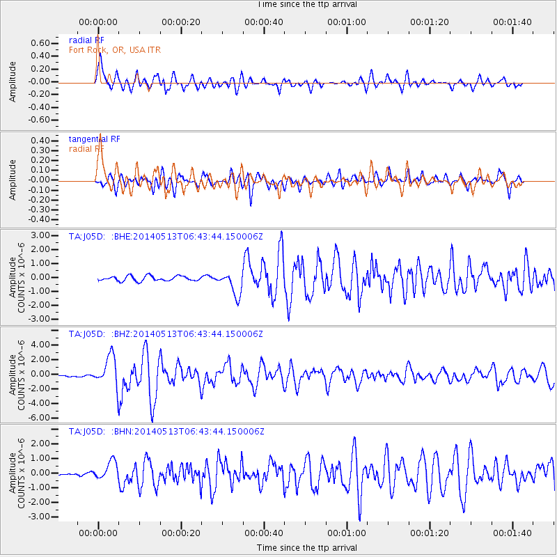
Signal To Noise
| Channel | StoN | STA | LTA |
| TA:J05D: :BHZ:20140513T06:43:44.150006Z | 16.368961 | 2.189397E-6 | 1.3375296E-7 |
| TA:J05D: :BHN:20140513T06:43:44.150006Z | 10.177266 | 6.686117E-7 | 6.569659E-8 |
| TA:J05D: :BHE:20140513T06:43:44.150006Z | 4.9876747 | 8.837093E-7 | 1.7717862E-7 |
| Arrivals |
| Ps | 1.5 SECOND |
| PpPs | 4.7 SECOND |
| PsPs/PpSs | 6.2 SECOND |


