You are here: Home > Network List > CI - Caltech Regional Seismic Network Stations List
> Station MPM Manuel Prospect Mine, California, USA > Earthquake Result Viewer
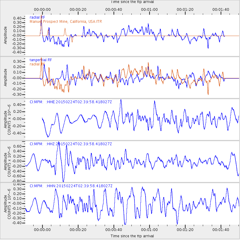
MPM Manuel Prospect Mine, California, USA - Earthquake Result Viewer
*The percent match for this event was below the threshold and hence no stack was calculated.
| Earthquake location: |
Off East Coast Of Honshu, Japan |
| Earthquake latitude/longitude: |
39.7/143.2 |
| Earthquake time(UTC): |
2015/02/24 (055) 02:28:54 GMT |
| Earthquake Depth: |
20 km |
| Earthquake Magnitude: |
5.8 MWB, 5.6 MWR, 5.8 MWC |
| Earthquake Catalog/Contributor: |
NEIC PDE/NEIC COMCAT |
|
| Network: |
CI Caltech Regional Seismic Network |
| Station: |
MPM Manuel Prospect Mine, California, USA |
| Lat/Lon: |
36.06 N/117.49 W |
| Elevation: |
185 m |
|
| Distance: |
74.2 deg |
| Az: |
56.194 deg |
| Baz: |
307.67 deg |
| Ray Param: |
$rayparam |
*The percent match for this event was below the threshold and hence was not used in the summary stack. |
|
| Radial Match: |
62.02427 % |
| Radial Bump: |
400 |
| Transverse Match: |
58.808475 % |
| Transverse Bump: |
400 |
| SOD ConfigId: |
7019011 |
| Insert Time: |
2019-04-17 01:19:45.621 +0000 |
| GWidth: |
2.5 |
| Max Bumps: |
400 |
| Tol: |
0.001 |
|
Signal To Noise
| Channel | StoN | STA | LTA |
| CI:MPM: :HHZ:20150224T02:39:58.418027Z | 0.33591104 | 6.016067E-8 | 1.7909703E-7 |
| CI:MPM: :HHN:20150224T02:39:58.418027Z | 0.8042842 | 1.3657898E-7 | 1.6981431E-7 |
| CI:MPM: :HHE:20150224T02:39:58.418027Z | 0.9463383 | 1.6028122E-7 | 1.6936988E-7 |
| Arrivals |
| Ps | |
| PpPs | |
| PsPs/PpSs | |


