You are here: Home > Network List > TA - USArray Transportable Network (new EarthScope stations) Stations List
> Station L48A N Adams, MI, USA > Earthquake Result Viewer
L48A N Adams, MI, USA - Earthquake Result Viewer
| Earthquake location: |
South Of Panama |
| Earthquake latitude/longitude: |
7.2/-82.3 |
| Earthquake time(UTC): |
2014/05/13 (133) 06:35:24 GMT |
| Earthquake Depth: |
10 km |
| Earthquake Magnitude: |
6.8 MWP, 6.8 MI |
| Earthquake Catalog/Contributor: |
NEIC PDE/NEIC COMCAT |
|
| Network: |
TA USArray Transportable Network (new EarthScope stations) |
| Station: |
L48A N Adams, MI, USA |
| Lat/Lon: |
41.94 N/84.43 W |
| Elevation: |
369 m |
|
| Distance: |
34.6 deg |
| Az: |
357.236 deg |
| Baz: |
176.324 deg |
| Ray Param: |
0.07765715 |
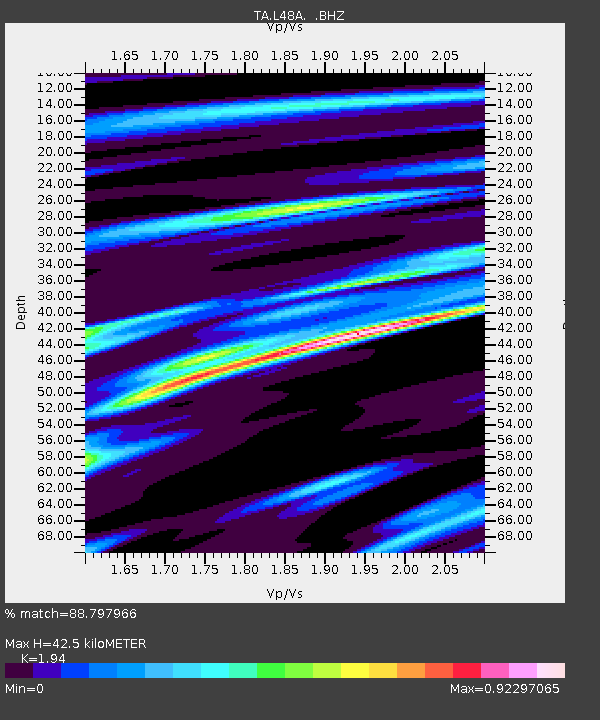
| Estimated Moho Depth: |
42.5 km |
| Estimated Crust Vp/Vs: |
1.94 |
| Assumed Crust Vp: |
6.498 km/s |
| Estimated Crust Vs: |
3.349 km/s |
| Estimated Crust Poisson's Ratio: |
0.32 |
|
| Radial Match: |
88.797966 % |
| Radial Bump: |
320 |
| Transverse Match: |
61.23259 % |
| Transverse Bump: |
400 |
| SOD ConfigId: |
626651 |
| Insert Time: |
2014-05-27 07:30:29.688 +0000 |
| GWidth: |
2.5 |
| Max Bumps: |
400 |
| Tol: |
0.001 |
|
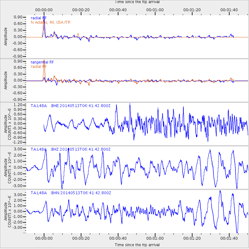
Signal To Noise
| Channel | StoN | STA | LTA |
| TA:L48A: :BHZ:20140513T06:41:42.800Z | 5.5962687 | 1.6335108E-6 | 2.9189283E-7 |
| TA:L48A: :BHN:20140513T06:41:42.800Z | 4.378546 | 1.0526983E-6 | 2.4042188E-7 |
| TA:L48A: :BHE:20140513T06:41:42.800Z | 0.8355047 | 1.8801613E-7 | 2.25033E-7 |
| Arrivals |
| Ps | 6.6 SECOND |
| PpPs | 18 SECOND |
| PsPs/PpSs | 25 SECOND |


