You are here: Home > Network List > TA - USArray Transportable Network (new EarthScope stations) Stations List
> Station L53A Girard, PA, USA > Earthquake Result Viewer
L53A Girard, PA, USA - Earthquake Result Viewer
| Earthquake location: |
South Of Panama |
| Earthquake latitude/longitude: |
7.2/-82.3 |
| Earthquake time(UTC): |
2014/05/13 (133) 06:35:24 GMT |
| Earthquake Depth: |
10 km |
| Earthquake Magnitude: |
6.8 MWP, 6.8 MI |
| Earthquake Catalog/Contributor: |
NEIC PDE/NEIC COMCAT |
|
| Network: |
TA USArray Transportable Network (new EarthScope stations) |
| Station: |
L53A Girard, PA, USA |
| Lat/Lon: |
41.95 N/80.26 W |
| Elevation: |
355 m |
|
| Distance: |
34.6 deg |
| Az: |
2.719 deg |
| Baz: |
183.617 deg |
| Ray Param: |
0.07765276 |
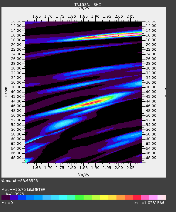
| Estimated Moho Depth: |
15.75 km |
| Estimated Crust Vp/Vs: |
2.00 |
| Assumed Crust Vp: |
6.483 km/s |
| Estimated Crust Vs: |
3.245 km/s |
| Estimated Crust Poisson's Ratio: |
0.33 |
|
| Radial Match: |
85.68926 % |
| Radial Bump: |
335 |
| Transverse Match: |
68.45456 % |
| Transverse Bump: |
400 |
| SOD ConfigId: |
626651 |
| Insert Time: |
2014-05-27 07:30:37.995 +0000 |
| GWidth: |
2.5 |
| Max Bumps: |
400 |
| Tol: |
0.001 |
|

Signal To Noise
| Channel | StoN | STA | LTA |
| TA:L53A: :BHZ:20140513T06:41:42.875012Z | 8.73463 | 1.4043468E-6 | 1.607792E-7 |
| TA:L53A: :BHN:20140513T06:41:42.875012Z | 5.812035 | 7.981581E-7 | 1.3732851E-7 |
| TA:L53A: :BHE:20140513T06:41:42.875012Z | 1.4972469 | 2.1849742E-7 | 1.459328E-7 |
| Arrivals |
| Ps | 2.6 SECOND |
| PpPs | 6.8 SECOND |
| PsPs/PpSs | 9.4 SECOND |


