You are here: Home > Network List > TA - USArray Transportable Network (new EarthScope stations) Stations List
> Station L59A Walton, NY, USA > Earthquake Result Viewer
L59A Walton, NY, USA - Earthquake Result Viewer
| Earthquake location: |
South Of Panama |
| Earthquake latitude/longitude: |
7.2/-82.3 |
| Earthquake time(UTC): |
2014/05/13 (133) 06:35:24 GMT |
| Earthquake Depth: |
10 km |
| Earthquake Magnitude: |
6.8 MWP, 6.8 MI |
| Earthquake Catalog/Contributor: |
NEIC PDE/NEIC COMCAT |
|
| Network: |
TA USArray Transportable Network (new EarthScope stations) |
| Station: |
L59A Walton, NY, USA |
| Lat/Lon: |
42.19 N/75.04 W |
| Elevation: |
677 m |
|
| Distance: |
35.4 deg |
| Az: |
9.367 deg |
| Baz: |
192.55 deg |
| Ray Param: |
0.07724899 |
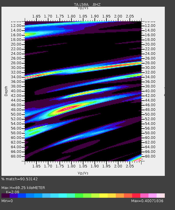
| Estimated Moho Depth: |
69.25 km |
| Estimated Crust Vp/Vs: |
2.09 |
| Assumed Crust Vp: |
6.419 km/s |
| Estimated Crust Vs: |
3.071 km/s |
| Estimated Crust Poisson's Ratio: |
0.35 |
|
| Radial Match: |
90.53142 % |
| Radial Bump: |
267 |
| Transverse Match: |
59.800713 % |
| Transverse Bump: |
379 |
| SOD ConfigId: |
626651 |
| Insert Time: |
2014-05-27 07:31:02.619 +0000 |
| GWidth: |
2.5 |
| Max Bumps: |
400 |
| Tol: |
0.001 |
|
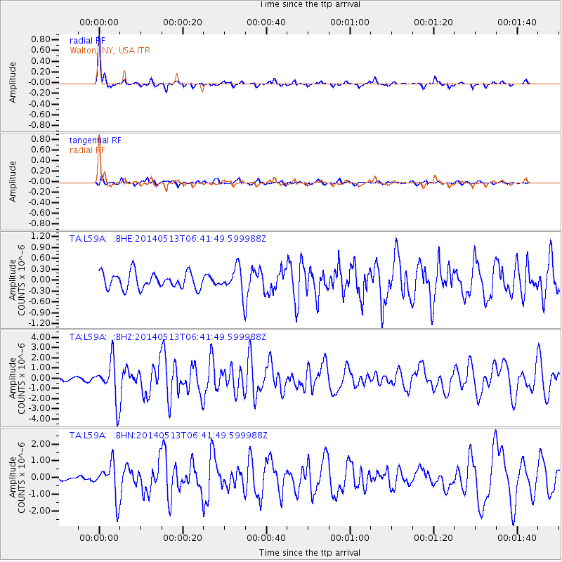
Signal To Noise
| Channel | StoN | STA | LTA |
| TA:L59A: :BHZ:20140513T06:41:49.599988Z | 10.738937 | 2.053248E-6 | 1.9119656E-7 |
| TA:L59A: :BHN:20140513T06:41:49.599988Z | 4.8137956 | 1.0704549E-6 | 2.2237234E-7 |
| TA:L59A: :BHE:20140513T06:41:49.599988Z | 1.7294891 | 3.7417414E-7 | 2.1634952E-7 |
| Arrivals |
| Ps | 13 SECOND |
| PpPs | 31 SECOND |
| PsPs/PpSs | 44 SECOND |


